Home > Europe > United Kingdom > Scotland > Strathclyde > Ayr
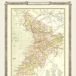
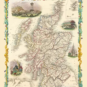
Old County Map of Ayr Scotland 1847 by A&C Black

![]()
Wall Art and Photo Gifts from MapSeeker
Old County Map of Ayr Scotland 1847 by A&C Black
A finely detailed facimile remastered in full colour from an antique original map of Ayr featured in A&C Blacks Atlas of 1847. Each Parish is numbered using an index table, colour rendition beautifully differentiating all of the Parishes. As well as principal roads, towns, villages and hamlets, these county maps of Scotland feature key battle sites marked with two crossed swords and the date of the battle
Welcome to the Mapseeker Image library and enter an historic gateway to one of the largest on-line collections of Historic Maps, Nostalgic Views, Vista's and Panorama's from a World gone by.
Media ID 20347453
© Mapseeker Publishing Ltd
A And C Black A And C Black Atlas A And C Black Map County Map County Map Of Scotland Historic Map Old County Map Old Scottish County Map Scottish County Map Ayrshire
FEATURES IN THESE COLLECTIONS
> Arts
> Photorealistic artworks
> Detailed art pieces
> Masterful detailing in art
> Europe
> United Kingdom
> Scotland
> Ayrshire
> Europe
> United Kingdom
> Scotland
> Maps
> Europe
> United Kingdom
> Scotland
> Strathclyde
> Ayr
> Maps and Charts
> Early Maps
> Maps and Charts
> Related Images
> MapSeeker
> Maps from the British Isles
> Scotland and Counties PORTFOLIO
EDITORS COMMENTS
This beautifully remastered print of the "Old County Map of Ayr Scotland 1847" takes us on a journey back in time to explore the rich history and intricate details of this Scottish county. Created by A&C Black, renowned cartographers of their time, this map is a true testament to their craftsmanship. The full-color facsimile showcases the stunning beauty and complexity of the original antique map featured in A&C Blacks Atlas. Each Parish is meticulously numbered using an index table, allowing for easy navigation and exploration. The vibrant colors elegantly differentiate between all the Parishes, bringing them to life on paper. Not only does this historic map highlight principal roads, towns, villages, and hamlets within Ayrshire but it goes beyond that. It also features key battle sites marked with two crossed swords alongside the date of each battle fought there. This inclusion adds another layer of historical significance to an already captivating piece. Whether you are a history enthusiast or simply appreciate fine artistry, this old county map offers a glimpse into Scotland's past like no other. Its detailed depiction invites you to immerse yourself in the landscapes and stories that shaped Ayrshire centuries ago. Hang this remarkable print proudly on your wall as both a conversation starter and a reminder of our shared heritage. Let it transport you back in time as you marvel at its intricacy and discover new facets about one of Scotland's most fascinating regions - Ayrshire
MADE IN THE USA
Safe Shipping with 30 Day Money Back Guarantee
FREE PERSONALISATION*
We are proud to offer a range of customisation features including Personalised Captions, Color Filters and Picture Zoom Tools
SECURE PAYMENTS
We happily accept a wide range of payment options so you can pay for the things you need in the way that is most convenient for you
* Options may vary by product and licensing agreement. Zoomed Pictures can be adjusted in the Cart.