Home > Arts > Photorealistic artworks > Detailed art pieces > Masterful detailing in art
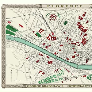
Old map of Southern Italy 1852 by Henry George Collins

![]()
Wall Art and Photo Gifts from MapSeeker
Old map of Southern Italy 1852 by Henry George Collins
This is a finely detailed map of Southern Italy remastered from a rare Atlas of the World published in 1852 by Henry George Collins. Although these Henry Collins produced maps of the highest quality in his time unfortunately not the same could be said in terms of his business success. His maps were later obtained by the famous Stanford Map Company and used in their publications
Welcome to the Mapseeker Image library and enter an historic gateway to one of the largest on-line collections of Historic Maps, Nostalgic Views, Vista's and Panorama's from a World gone by.
Media ID 20347261
© Mapseeker Publishing Ltd
Collins Collins Atlas Collins Atlas Map Collins Map South Italy Southern Italy
FEATURES IN THESE COLLECTIONS
> Arts
> Photorealistic artworks
> Detailed art pieces
> Masterful detailing in art
> Maps and Charts
> Italy
> Maps and Charts
> Related Images
> Maps and Charts
> World
> MapSeeker
> Maps of Europe
> Maps of Italy PORTFOLIO
EDITORS COMMENTS
This beautifully preserved print showcases an exquisite old map of Southern Italy, meticulously crafted by the talented cartographer Henry George Collins in 1852. Remastered from a rare Atlas of the World, this particular map is a testament to Collins' exceptional skill and attention to detail. Despite his undeniable talent, Henry Collins did not achieve great success in terms of business ventures. However, his maps found new life when they were acquired by the renowned Stanford Map Company and incorporated into their publications. The map itself provides a captivating glimpse into the past, offering insights into the geographical landscape and historical context of Southern Italy during that era. It serves as a valuable resource for historians, geographers, or anyone with an interest in Italian history. With its intricate markings and carefully delineated boundaries, this old map transports us back to a time when exploration was at its peak and cartography was both an art form and scientific endeavor. The delicate lines tracing coastlines, rivers, cities, and mountain ranges evoke a sense of wonder about how our world has evolved over time. Whether you are fascinated by vintage maps or have an affinity for Italian culture and heritage, this stunning print will undoubtedly captivate your imagination while providing invaluable insight into Southern Italy's rich history.
MADE IN THE USA
Safe Shipping with 30 Day Money Back Guarantee
FREE PERSONALISATION*
We are proud to offer a range of customisation features including Personalised Captions, Color Filters and Picture Zoom Tools
SECURE PAYMENTS
We happily accept a wide range of payment options so you can pay for the things you need in the way that is most convenient for you
* Options may vary by product and licensing agreement. Zoomed Pictures can be adjusted in the Cart.