Home > Europe > Malta > Maps
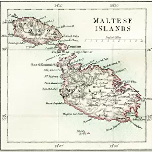
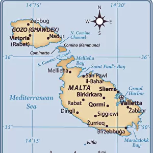
Map of Malta. Island. Mediterranean Sea. Italian engraving

![]()
Wall Art and Photo Gifts from Mary Evans Picture Library
Map of Malta. Island. Mediterranean Sea. Italian engraving
Map of Malta. Island. Mediterranean Sea. Italian engraving. 16th century
Mary Evans Picture Library makes available wonderful images created for people to enjoy over the centuries
Media ID 14337070
© Thaliastock / Mary Evans
1558 Cartography Malta Mapping Mediterranean
FEATURES IN THESE COLLECTIONS
> Europe
> Italy
> Related Images
> Europe
> Malta
> Related Images
> Europe
> Related Images
> Maps and Charts
> Early Maps
EDITORS COMMENTS
1. Title: "A Glimpse into the Past: A 16th Century Italian Engraving of the Island of Malta and the Mediterranean Sea" This print showcases an intricately detailed Italian engraving of the Island of Malta and the surrounding Mediterranean Sea, dating back to the 16th century. The map, created in 1558, is an exquisite example of ancient cartography and the European mapping age. The Island of Malta, located in the central Mediterranean, is depicted with remarkable accuracy for the time, with its three main islands - Malta, Gozo, and Comino - clearly visible. The engraving also reveals the strategic importance of the island, as it lies at the crossroads of major sea routes connecting Europe, North Africa, and the Middle East. The intricate details of the map extend beyond Malta, with an accurate representation of the Mediterranean Sea, including various islands and coastal features. The map's title, "Isola di Malta," is inscribed in elegant script at the top, while the surrounding waters are labeled with the names of various countries and regions, such as "Francia" (France) and "Repubblica di Genova" (Genoa). This 16th-century Italian engraving offers a fascinating glimpse into the past, providing valuable insights into the historical geography and cartography of the Mediterranean region during the Age of Discovery. The intricate details and beautiful design make it an essential addition to any collection focused on ancient maps, European history, or the Mediterranean world. The Island of Malta has a rich and complex history, having been ruled by various powers, including the Phoenicians, Romans, Arabs, Normans, and the Knights of St. John. In the late 16th century, the island came under the rule of the Spanish, which is likely why this Italian engraving was produced. The map serves as a testament to the island's strategic importance and the advanced cartographic knowledge of the time.
MADE IN THE USA
Safe Shipping with 30 Day Money Back Guarantee
FREE PERSONALISATION*
We are proud to offer a range of customisation features including Personalised Captions, Color Filters and Picture Zoom Tools
SECURE PAYMENTS
We happily accept a wide range of payment options so you can pay for the things you need in the way that is most convenient for you
* Options may vary by product and licensing agreement. Zoomed Pictures can be adjusted in the Cart.