Home > Science > Space Exploration > Planets > Earth
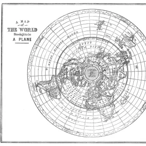
PARALLELS OF LONGITUDE

![]()
Wall Art and Photo Gifts from Mary Evans Picture Library
PARALLELS OF LONGITUDE
Parallels of longitude, relative to the Equator Date: circa 1690
Mary Evans Picture Library makes available wonderful images created for people to enjoy over the centuries
Media ID 20146585
© Bubblepunk
1690 Earth Equator Globe Globes Longitude Maps Phenomena Planet Planets Relative Space Parallels
FEATURES IN THESE COLLECTIONS
> Maps and Charts
> Related Images
> Mary Evans Prints Online
> New Images July 2020
> Science
> Space Exploration
> Planets
> Earth
EDITORS COMMENTS
Parallels of Longitude: A Glimpse into the Fascinating World of Early Geographical Understanding (circa 1690) This print, showcasing the Parallels of Longitude relative to the Equator, offers a glimpse into the intriguing world of early geographical understanding. Dating back to circa 1690, this natural phenomenon illustration is a testament to the intellectual curiosity and exploratory spirit of the time. The Parallels of Longitude, represented by the concentric circles on this map, are imaginary lines of equal latitude that encircle the Earth. They run perpendicular to the Equator and are spaced apart by a constant angle of approximately 111.3 kilometers. This regular spacing is due to the Earth's oblate spheroidal shape, meaning it is slightly flattened at the poles and bulging at the equator. The Earth's rotation around its own axis causes the Sun's rays to hit the Earth at different angles at various latitudes, leading to distinct climatic zones. The Parallels of Longitude, therefore, mark significant divisions in the natural world, influencing various phenomena such as climate, vegetation, and animal distribution. This print, which could have been used as a reference for creating globes or maps, demonstrates the early European understanding of the Earth's geography. It is a reminder of the remarkable progress made in mapping the world during this period, as explorers and cartographers sought to unravel the mysteries of the universe and expand human knowledge. The Parallels of Longitude print, with its intricate details and meticulous accuracy, stands as a testament to the ingenuity and curiosity of the human mind. It invites us to marvel at the wonders of the cosmos and to continue exploring the vast, interconnected web of natural phenomena that make up our world.
MADE IN THE USA
Safe Shipping with 30 Day Money Back Guarantee
FREE PERSONALISATION*
We are proud to offer a range of customisation features including Personalised Captions, Color Filters and Picture Zoom Tools
SECURE PAYMENTS
We happily accept a wide range of payment options so you can pay for the things you need in the way that is most convenient for you
* Options may vary by product and licensing agreement. Zoomed Pictures can be adjusted in the Cart.