Home > Mary Evans Prints Online > New Images July 2023
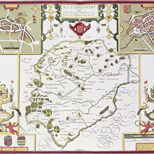
1840s Victorian Map of Rutland

![]()
Wall Art and Photo Gifts from Mary Evans Picture Library
1840s Victorian Map of Rutland
Mary Evans Picture Library makes available wonderful images created for people to enjoy over the centuries
Media ID 32350872
© The Keasbury-Gordon Photograph Archive / Mary Evans
1840s Oakham Railways Rutland Stamford Uppingham
FEATURES IN THESE COLLECTIONS
> Europe
> United Kingdom
> England
> Maps
> Europe
> United Kingdom
> England
> Posters
> Europe
> United Kingdom
> England
> Railways
> Europe
> United Kingdom
> England
> Related Images
> Europe
> United Kingdom
> England
> Rutland
> Oakham
> Europe
> United Kingdom
> England
> Rutland
> Related Images
> Europe
> United Kingdom
> England
> Rutland
> Uppingham
> Maps and Charts
> Early Maps
> Maps and Charts
> Related Images
> Mary Evans Prints Online
> New Images July 2023
> Popular Themes
> Railway Posters
EDITORS COMMENTS
This stunning vintage lantern slide captures a glimpse into the past with an 1840s Victorian map of Rutland, England. The intricate details and craftsmanship of this historical piece showcase the beauty and complexity of cartography during the Victorian era.
The map depicts the charming towns of Stamford, Oakham, and Uppingham, as well as the various railways that crisscrossed through the county. Each line on the map tells a story of transportation and connectivity in a time when travel was much more arduous than it is today.
As we gaze upon this Edwardian-era treasure, we are transported back to a time when horse-drawn carriages were still a common sight on rutted country roads. The meticulous attention to detail in this map speaks to the dedication and skill of its creators, who painstakingly recorded every road, river, and railway line with precision.
This print from The Keasbury-Gordon Photograph Archive Collection is not just a piece of history; it is a work of art that showcases both the technological advancements of its time and the enduring beauty of hand-drawn maps. It serves as a reminder of how far we have come in terms of navigation and transportation while also highlighting the timeless appeal of vintage cartography.
MADE IN THE USA
Safe Shipping with 30 Day Money Back Guarantee
FREE PERSONALISATION*
We are proud to offer a range of customisation features including Personalised Captions, Color Filters and Picture Zoom Tools
SECURE PAYMENTS
We happily accept a wide range of payment options so you can pay for the things you need in the way that is most convenient for you
* Options may vary by product and licensing agreement. Zoomed Pictures can be adjusted in the Cart.