Brazil, relief map
![]()

Wall Art and Photo Gifts from Science Photo Library
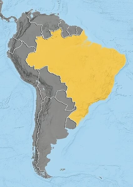
Brazil, relief map
Brazil. North is at top. Relief map of Brazil (yellow) in South America, showing the borders (white lines) of the surrounding countries. Brazil is bordered on the north by Venezuela, Guyana, Suriname and the French overseas region of French Guiana; on the northwest by Colombia; on the west by Bolivia and Peru; on the southwest by Argentina and Paraguay and on the south by Uruguay. The Atlantic Ocean (blue, right), Pacific Ocean (blue, left), and Caribbean Sea (blue, top left) can also be seen. Image compiled using elevation data, in 2012
Science Photo Library features Science and Medical images including photos and illustrations
Media ID 9217895
© PLANETOBSERVER/SCIENCE PHOTO LIBRARY
2012 Atlantic Birds Eye View Border Borders Boundaries Boundary Brasil Brazil Caribbean Sea Cartography Continent Continents Countries Country Earth Observation Elevation Elevations Environmental From Above Frontier Frontiers Land Nation Nations Oceans Pacific Relief Relief Map South America South American Topographic Topography
EDITORS COMMENTS
This print showcases a relief map of Brazil, with the northern region positioned at the top. The vibrant yellow hues beautifully depict the diverse landscape of this South American country. White lines meticulously trace the borders that connect Brazil to its neighboring nations. To the north, Venezuela, Guyana, Suriname, and French Guiana can be seen alongside Colombia in the northwest. Bolivia and Peru mark Brazil's western border while Argentina and Paraguay lie to its southwest. Uruguay completes this intricate puzzle by forming Brazil's southern boundary. The image also reveals three vast bodies of water surrounding this magnificent landmass: the Atlantic Ocean on the right side, Pacific Ocean on the left side, and Caribbean Sea at the top left corner. This comprehensive view was compiled using elevation data in 2012, providing an accurate representation of Brazil's topography. As we observe this aerial perspective captured from above Earth's surface, it becomes evident how crucial cartography is in understanding our planet's geography. The intricate details showcased here emphasize not only national boundaries but also highlight environmental factors such as elevations and oceanic influences. This remarkable photograph serves as a testament to both scientific exploration and artistic appreciation for our world's natural wonders.
MADE IN THE USA
Safe Shipping with 30 Day Money Back Guarantee
FREE PERSONALISATION*
We are proud to offer a range of customisation features including Personalised Captions, Color Filters and Picture Zoom Tools
SECURE PAYMENTS
We happily accept a wide range of payment options so you can pay for the things you need in the way that is most convenient for you
* Options may vary by product and licensing agreement. Zoomed Pictures can be adjusted in the Cart.

