Home > Europe > United Kingdom > England > Yorkshire > Crookesmoor
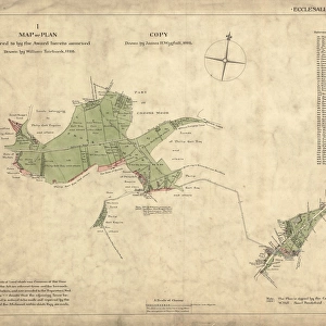
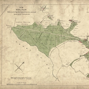
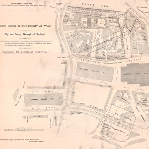
Ordnance Survey Map, Sheffield, Banner Street area, Crookes, Sheffield, 1889 (Yorkshire sheet 294. 7. 8)
")
![]()
Wall Art and Photo Gifts from Sheffield City Archives
Ordnance Survey Map, Sheffield, Banner Street area, Crookes, Sheffield, 1889 (Yorkshire sheet 294. 7. 8)
This map features
Top left: Springvale Road, Alpine Road, Upperthorpe, Ashberry Road, Sydney Road, Banner Road, Wellfield House, Glen Roy, Albert Villa, Oak Tower, Logan Bank, The Laurels, Marlborough Villas, Vale Mount, Greno House, Acorn Villa, White Thorns, Westmoreland Villa, Spring Bank, Ash Villa, Oak Villa, Kirkstall Villa, Foundry House, Rose Villa, Ormside.
Top right: Springvale Road, Ashberry Road, Banner Road, Crookesmoor Road, Arthur Street, Cross Addey Street, Addey Street, Norfolk Terrace, Horam Road, Ada Street, Blake House Terrace, St. Johns Hall, Hope Terrace, Myrtle Place, Brunswick Terrace.
Bottom left: Sydney Road, Banner Road, Sydney Villa, Burns Road, Roebuck Road, Chatwin Street, Prospect Place, Crookesmoor Road, Elder Grove, Woodbourne Place, Springvale View, Barber Crescent, Prospect Terrace, Manor View, Bank View, Barber Nook.
Bottom right: Ashberry Road, Chatwin Street, Prospect Place, Crookesmoor Road, Addey Street, Norfolk Terrace, Horam Road, Louisiana Place, Vestry Street, Vestry Office, Crookesmoor Board School, Crookesmoor, playground, Hampden Place, Wentworth Villas, United Methodist Free Church, Oxford Street (junction with Bond Steet), Bond Street, Martin Street, Albion Street, Oxford Street, Bloomsbury Place, Bloomsbury Hotel Public House, Durham Place, Wentworth Street.
Dimensions of original: 77 x 102 cm.
Scale 10.56 feet : 1 mile [1:500].
From an original at Sheffield Libraries: q00052 (sheet No. 294.7.8)
Sheffield City Archives and Local Studies Library has an unrivalled collection of images of Sheffield, England
Media ID 25801021
© Sheffield City Council - All Rights Reserved
FEATURES IN THESE COLLECTIONS
> Animals
> Insects
> Hemiptera
> Hall Scale
> Animals
> Insects
> Hemiptera
> Rose Scale
> Architecture
> Towers
> Churches
> Europe
> United Kingdom
> England
> Durham
> Durham
> Europe
> United Kingdom
> England
> Norfolk
> Related Images
> Europe
> United Kingdom
> England
> Yorkshire
> Burn
> Europe
> United Kingdom
> England
> Yorkshire
> Crookes
> Europe
> United Kingdom
> England
> Yorkshire
> Crookesmoor
> Europe
> United Kingdom
> England
> Yorkshire
> Kirkstall
> Europe
> United Kingdom
> England
> Yorkshire
> Sheffield
> Sheffield City Archives
> Maps and Plans
> Sheffield OS maps
EDITORS COMMENTS
This print showcases an Ordnance Survey Map of the Banner Street area in Crookes, Sheffield, dating back to 1889. The map, known as Yorkshire sheet 294.7.8, offers a fascinating glimpse into the city's past. In the top left corner of the map, we can see Springvale Road and Alpine Road intersecting with other notable streets like Upperthorpe and Ashberry Road. The names of various houses such as Wellfield House, Glen Roy, and Oak Tower add a touch of nostalgia to this historical document. Moving to the top right section of the map, Crookesmoor Road takes center stage alongside Arthur Street and Norfolk Terrace. Notable landmarks include St. Johns Hall and Brunswick Terrace among others. The bottom left portion reveals Sydney Road leading to Burns Road while passing by Prospect Place and Elder Grove. This part also highlights Woodbourne Place and Manor View along with Barber Crescent. Lastly, in the bottom right quadrant lies Chatwin Street intersecting with Prospect Place near Crookesmoor Board School. Other significant locations featured are Oxford Street (junction with Bond Steet), Albion Street, Durham Place, Bloomsbury Hotel Public House among many others. Measuring at an impressive 77 x 102 cm in its original form, this meticulously detailed map is scaled at 10.56 feet:1 mile [1:500]. Preserved within Sheffield Libraries' archives under reference number q00052 (sheet No. 294.7.8), this remarkable piece invites us to explore Sheffield's rich history through its intricate street layout and architectural landmarks from over a century ago.
MADE IN THE USA
Safe Shipping with 30 Day Money Back Guarantee
FREE PERSONALISATION*
We are proud to offer a range of customisation features including Personalised Captions, Color Filters and Picture Zoom Tools
SECURE PAYMENTS
We happily accept a wide range of payment options so you can pay for the things you need in the way that is most convenient for you
* Options may vary by product and licensing agreement. Zoomed Pictures can be adjusted in the Cart.