Home > Asia > Sri Lanka > Maps
Sri Lanka. February 2000 - The topography of the island nation of Sri Lanka

![]()
Wall Art and Photo Gifts from Stocktrek
Sri Lanka. February 2000 - The topography of the island nation of Sri Lanka
February 2000 - The topography of the island nation of Sri Lanka is well shown in this color-coded shaded relief map generated with digital elevation data from the Shuttle Radar Topography Mission (SRTM).
Two visualization methods were combined to produce the image: shading and color coding of topographic height. The shade image was derived by computing topographic slope in the northwest-southeast direction, so that northwest slopes appear bright and southeast slopes appear dark. Color coding is directly related to topographic height, with green at the lower elevations, rising through yellow and tan, to white at the highest elevations.
For this special view heights below 10 meters (33 feet) above sea level have been colored red. These low coastal elevations extend 5 to 10 km (3.1 to 6.2 mi) inland on Sri Lanka and are especially vulnerable to flooding associated with storm surges, rising sea level, or, as in the aftermath of the earthquake of December 26, 2004, tsunami. These so-called tidal waves have occurred numerous times in history and can be especially destructive, but with the advent of the near-global SRTM elevation data planners can better predict which areas are in the most danger and help develop mitigation plans in the event of particular flood events.
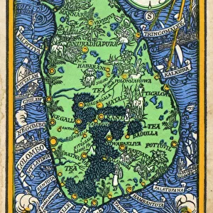
Sri Lanka is shaped like a giant teardrop falling from the southern tip of the vast Indian subcontinent. It is separated from India by the 50km (31mi) wide Palk Strait, although there is a series of stepping-stone coral islets known as Adams Bridge that almost form a land bridge between the two countries. The island is just 350km (217mi) long and only 180km (112mi) wide at its broadest, and is about the same size as Ireland, West Virginia or Tasmania.
The southern half of the island is dominated by beautiful and rugged hill country, and includes Mt Pidurutalagala, the islands highest point at 2524 meters (8281 ft). The entire northern half comprises a large plain extending from the edge of the hill country to the Jaffna peninsula
Stocktrek Images specializes in Astronomy, Dinosaurs, Medical, Military Forces, Ocean Life, & Sci-Fi
Media ID 13060893
© Stocktrek Images
Climate Change Coast Coastline Elevated Elevation Geography Global Warming Island Land Feature Landform Landmass Mountain Mountainous Relief Map Rugged Terrain Territory Topography Jaffna Sri Lanka View From Space
FEATURES IN THESE COLLECTIONS
> Europe
> Republic of Ireland
> Maps
EDITORS COMMENTS
This stunning print captures the diverse topography of Sri Lanka, showcasing its unique shape and geographical features. The image, created using digital elevation data from the Shuttle Radar Topography Mission (SRTM), combines shading and color coding to depict the island's varying elevations. The shade image reveals the northwest-southeast slope of the land, with brighter shades representing northwest slopes and darker shades representing southeast slopes. Meanwhile, the color coding directly corresponds to topographic height, with green indicating lower elevations and white symbolizing the highest points. Notably, this view highlights areas below 10 meters above sea level in red, emphasizing their vulnerability to flooding caused by storm surges or rising sea levels. These low coastal regions extend several kilometers inland and have historically been prone to destructive tidal waves like those experienced after the devastating earthquake of December 26,2004. By utilizing SRTM elevation data on a global scale, experts can now better predict high-risk areas for flooding events and develop effective mitigation plans. This valuable information aids planners in safeguarding vulnerable communities from potential disasters. Sri Lanka itself is shaped like a teardrop falling from India's southern tip. Separated by the Palk Strait but connected by coral islets known as Adams Bridge, it spans just over 350 kilometers in length and approximately 180 kilometers at its widest point. The southern half boasts rugged hill country dominated by Mt Pidurutalagala – standing tall at 2524 meters – while the northern half comprises a vast plain extending towards Jaffna peninsula. Overall, this print not only showcases Sri Lanka's natural beauty but also serves as a reminder of its susceptibility to environmental challenges that require careful planning and preparedness measures.
MADE IN THE USA
Safe Shipping with 30 Day Money Back Guarantee
FREE PERSONALISATION*
We are proud to offer a range of customisation features including Personalised Captions, Color Filters and Picture Zoom Tools
SECURE PAYMENTS
We happily accept a wide range of payment options so you can pay for the things you need in the way that is most convenient for you
* Options may vary by product and licensing agreement. Zoomed Pictures can be adjusted in the Cart.