Rights Managed > Universal Images Group (UIG) > Art > Painting, Sculpture & Prints > Cartography
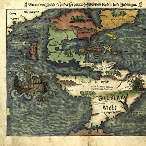
Central America, from Portuguese planisphere, 1550

Filename: 940_18_11204354.jpg
Size: 3499 x 2767 (5.1MB)
Date: 12th March 2014
Source: Universal Images Group (UIG)
Source: De Agostini Picture Library
© DEA / G. DAGLI ORTI
![]()
Wall Art and Photo Gifts from Universal Images Group (UIG)
Central America, from Portuguese planisphere, 1550
Cartography, 16th century. Central America. From a Portuguese planisphere, 1550. Detail
Universal Images Group (UIG) manages distribution for many leading specialist agencies worldwide
Media ID 9501507
© DEA / G. DAGLI ORTI
16th Century Central America Coat Of Arms Colonialism Flag Guidance Mexico Western Script World Map Antilles Islands The Americas
EDITORS COMMENTS
This print showcases a remarkable piece of cartography from the 16th century. Titled "Central America, from Portuguese planisphere, 1550" this image takes us back in time to an era of exploration and colonialism. The intricate details and artistry displayed on this map are truly awe-inspiring. The map features Central America prominently, with its distinctive coat of arms proudly displayed. It provides a glimpse into the historical significance of this region during that period. The grid lines and guidance symbols indicate meticulous attention to detail by the cartographer. As we delve deeper into the image, our eyes are drawn to the vast surrounding sea, symbolizing both adventure and uncertainty for those brave explorers who embarked on voyages across uncharted waters. This map serves as a testament to their courage and determination. The horizontal composition allows us to appreciate the entirety of Central America within its geographical context while also capturing glimpses of neighboring regions such as Mexico and the Antilles Islands. The use of Western script adds another layer of historical significance, reflecting cultural influences prevalent during that time. Notably absent are any human figures; instead, it is solely dedicated to illustrating landmasses, flags, and other essential elements. This print offers a fascinating window into history—a visual representation that transcends time—inviting us to reflect upon past civilizations' achievements in mapping out our world.
MADE IN THE USA
Safe Shipping with 30 Day Money Back Guarantee
FREE PERSONALISATION*
We are proud to offer a range of customisation features including Personalised Captions, Color Filters and Picture Zoom Tools
SECURE PAYMENTS
We happily accept a wide range of payment options so you can pay for the things you need in the way that is most convenient for you
* Options may vary by product and licensing agreement. Zoomed Pictures can be adjusted in the Cart.