Rights Managed > Universal Images Group (UIG) > Art > Painting, Sculpture & Prints > Cartography
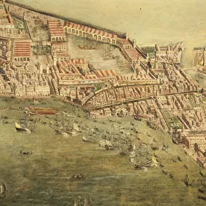
Dominican Republic, Santo Domingo, engraving from atlas

Filename: 940_18_11288705.jpg
Size: 4900 x 3162 (6.7MB)
Date: 12th March 2014
Source: Universal Images Group (UIG)
Source: De Agostini Picture Library
© DEA PICTURE LIBRARY
![]()
Wall Art and Photo Gifts from Universal Images Group (UIG)
Dominican Republic, Santo Domingo, engraving from atlas
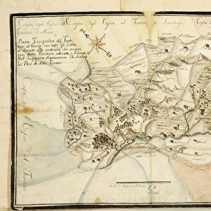
Cartography, Dominican Republic, 17th century. Santo Domingo. Engraving from an atlas from the 17th century
Universal Images Group (UIG) manages distribution for many leading specialist agencies worldwide
Media ID 9501417
© DEA PICTURE LIBRARY
16th Century Aerial View Boundary Coastline Dominican Republic Field Guidance Hill Human Settlement Navigational Equipment River Santo Domingo Surrounding Wall Text Town Townscape Veneto Wall Western Script Non Urban Scene Treviso
EDITORS COMMENTS
This print takes us back in time to the enchanting Dominican Republic of the 17th century. The image showcases an exquisite engraving from an atlas, depicting the vibrant city of Santo Domingo. As we gaze upon this historical artwork, we are transported to a world where cartography was meticulously crafted by skilled hands. The scene unfolds with a panoramic view of Santo Domingo, nestled amidst rolling hills and surrounded by a protective wall. The town's architecture is beautifully illustrated, showcasing its unique blend of Italian and Veneto influences. A river gracefully meanders through the landscape, leading towards the sparkling sea that stretches beyond our sight. Every detail has been carefully captured in this topographical masterpiece - from the text inscriptions guiding travelers to various towns and landmarks, to navigational equipment symbolizing exploration and discovery. It is as if we can almost hear echoes of history whispering through these ancient streets. As we immerse ourselves in this non-urban scene devoid of human presence, it becomes evident that this print serves as both a work of art and a valuable historical document. It offers us glimpses into the past - a testament to how human settlements have evolved over time along coastlines like these. This remarkable print invites us on a journey through time; it allows us to appreciate not only the beauty of Santo Domingo but also its rich cultural heritage and significance in shaping Dominican history.
MADE IN THE UK
Safe Shipping with 30 Day Money Back Guarantee
FREE PERSONALISATION*
We are proud to offer a range of customisation features including Personalised Captions, Color Filters and Picture Zoom Tools
SECURE PAYMENTS
We happily accept a wide range of payment options so you can pay for the things you need in the way that is most convenient for you
* Options may vary by product and licensing agreement. Zoomed Pictures can be adjusted in the Basket.