Rights Managed > Universal Images Group (UIG) > Art > Painting, Sculpture & Prints > Cartography
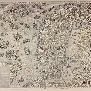
Finland and Russian territories, from Carta Marina, Sea Map by Olaus Magnus, Venice, detail, 1539

Filename: 940_18_11205125.jpg
Size: 4938 x 3939 (8.7MB)
Date: 16th March 2014
Source: Universal Images Group (UIG)
Source: De Agostini Picture Library
© DEA / M. SEEMULLER
![]()
Wall Art and Photo Gifts from Universal Images Group (UIG)
Finland and Russian territories, from Carta Marina, Sea Map by Olaus Magnus, Venice, detail, 1539
Cartography, 16th century. Finland and Russian territories. From Carta Marina (Sea Map) by Olaus Magnus, Venice, 1539. Detail
Universal Images Group (UIG) manages distribution for many leading specialist agencies worldwide
Media ID 9571547
© DEA / M. SEEMULLER
16th Century Coastline Estonia Finland Guidance Gulf Sailing Ship Olaus Magnus
EDITORS COMMENTS
This print showcases a stunning detail from the historic Carta Marina, a sea map created by Olaus Magnus in 1539. The focus of this particular section is Finland and Russian territories, offering us a glimpse into the cartography of the 16th century. The intricate illustration and painting on this map provide invaluable insights into the geography and history of Europe during that era. With its horizontal orientation, it allows viewers to immerse themselves in the vastness of these lands. As we explore this image, our eyes are drawn to the Gulf of Finland, which separates these two regions. The coastline stretches out before us with remarkable accuracy for its time, highlighting key landmarks such as Estonia. This detailed depiction serves as both guidance and inspiration for travel enthusiasts or those interested in maritime history. It transports us back to a time when sailing ships dominated these waters, evoking a sense of adventure and discovery. Although devoid of people, this print speaks volumes about the significant role played by cartographers like Olaus Magnus in documenting our world's ever-changing landscapes. Its historical significance cannot be overstated. In summary, this mesmerizing print offers an extraordinary glimpse into 16th-century cartography through Olaus Magnus' masterpiece - Carta Marina. It invites us to appreciate not only the beauty but also the importance of maps as tools for exploration and understanding our past.
MADE IN THE USA
Safe Shipping with 30 Day Money Back Guarantee
FREE PERSONALISATION*
We are proud to offer a range of customisation features including Personalised Captions, Color Filters and Picture Zoom Tools
SECURE PAYMENTS
We happily accept a wide range of payment options so you can pay for the things you need in the way that is most convenient for you
* Options may vary by product and licensing agreement. Zoomed Pictures can be adjusted in the Cart.