Rights Managed > Universal Images Group (UIG) > Art > Painting, Sculpture & Prints > Cartography
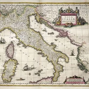
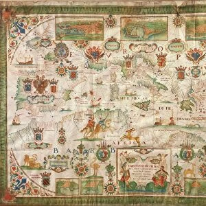
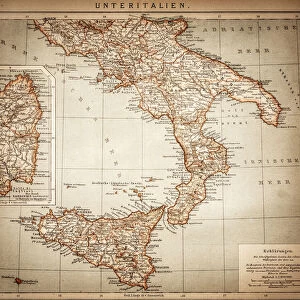
Map of Calabria region, by Joan Blaeu

Filename: 940_18_10392439.jpg
Size: 6510 x 5030 (13.1MB)
Date: 12th March 2014
Source: Universal Images Group (UIG)
Source: De Agostini Picture Library
© DEA PICTURE LIBRARY
![]()
Wall Art and Photo Gifts from Universal Images Group (UIG)
Map of Calabria region, by Joan Blaeu
Cartography, Italy, 17th century. Map of Calabria region, by Joan Blaeu
Universal Images Group (UIG) manages distribution for many leading specialist agencies worldwide
Media ID 9502979
© DEA PICTURE LIBRARY
17th Century Calabria Cherub Coastline Coat Of Arms Compass Rose Fictional Being Italian Culture Joan Blaeu Nautical Vessel Sailing Boat Transportation Western Script
EDITORS COMMENTS
This print showcases a remarkable piece of cartography from the 17th century - the "Map of Calabria region" by Joan Blaeu. With its full-length view, this studio shot allows us to admire every intricate detail of this historical map. The Map of Calabria region features a stunning combination of art and craft, depicting the physical geography and coastline with precision. At first glance, one cannot help but notice the coat of arms proudly displayed in the corner, representing the rich history and culture of Italy. A cherub gracefully hovers above a sailing boat on the sea, symbolizing both transportation and exploration during that era. The map itself is adorned with various elements such as a compass rose and Western script labels, providing valuable information about different locations within Calabria. It serves as an invaluable resource for understanding Italian culture and heritage. Through this photo print, we are transported back in time to witness how cartographers like Joan Blaeu meticulously created these works of art. While there are no people present in this image, it evokes curiosity about those who would have used such maps centuries ago. This print not only captures an important part of history but also celebrates the skillful craftsmanship behind it. It serves as a reminder that even fictional beings can leave their mark on our world through their artistic creations.
MADE IN THE USA
Safe Shipping with 30 Day Money Back Guarantee
FREE PERSONALISATION*
We are proud to offer a range of customisation features including Personalised Captions, Color Filters and Picture Zoom Tools
SECURE PAYMENTS
We happily accept a wide range of payment options so you can pay for the things you need in the way that is most convenient for you
* Options may vary by product and licensing agreement. Zoomed Pictures can be adjusted in the Cart.