Rights Managed > Universal Images Group (UIG) > Art > Painting, Sculpture & Prints > Cartography
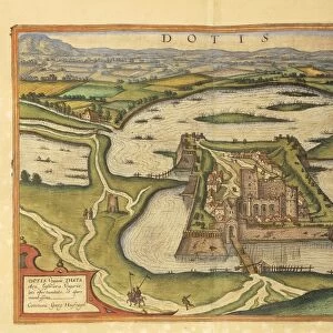
Map of Fontainebleau castle from Civitates Orbis Terrarum by Georg Braun, 1541-1622 and Franz Hogenberg, 1540-1590, engraving

Filename: 940_18_90012065.jpg
Size: 3573 x 5406 (9.3MB)
Date: 12th March 2014
Source: Universal Images Group (UIG)
Source: De Agostini Picture Library
© DEA / A. DAGLI ORTI
![]()
Wall Art and Photo Gifts from Universal Images Group (UIG)
Map of Fontainebleau castle from Civitates Orbis Terrarum by Georg Braun, 1541-1622 and Franz Hogenberg, 1540-1590, engraving
Cartography, France, 16th century. Map of Fontainebleau castle. From Civitates Orbis Terrarum by Georg Braun (1541-1622) and Franz Hogenberg (1540-1590), Cologne. Engraving
Universal Images Group (UIG) manages distribution for many leading specialist agencies worldwide
Media ID 9501495
© DEA / A. DAGLI ORTI
16th Century Civitates Orbis Terrarum Fontainebleau Formal Garden Franz Hogenberg French Culture Georg Braun Palace Plan Western Script
EDITORS COMMENTS
This print showcases a remarkable map of Fontainebleau castle, taken from the renowned Civitates Orbis Terrarum by Georg Braun and Franz Hogenberg. Created in the 16th century, this antique engraving offers a fascinating glimpse into the palace's rich history and exquisite architecture. The vertical composition of the map allows for an intricate depiction of Fontainebleau castle, highlighting its grandeur and majesty. The detailed cartography transports us back in time to explore the layout of this iconic French landmark. With Western script annotations, it provides valuable insights into the geography and planning of the castle grounds. Notably absent are human figures, allowing us to focus solely on appreciating the architectural marvels that await within Fontainebleau's walls. The formal gardens surrounding the palace are beautifully illustrated, showcasing their meticulous design and adding to our understanding of French culture during this period. As part of Civitates Orbis Terrarum - a groundbreaking atlas documenting cities around the world - this engraving holds significant historical value. It serves as a testament to Braun and Hogenberg's dedication to capturing important landmarks across Europe. Whether you're an enthusiast of cartography or simply intrigued by France's rich heritage, this stunning print is sure to captivate your imagination with its blend of artistry and historical significance.
MADE IN THE UK
Safe Shipping with 30 Day Money Back Guarantee
FREE PERSONALISATION*
We are proud to offer a range of customisation features including Personalised Captions, Color Filters and Picture Zoom Tools
SECURE PAYMENTS
We happily accept a wide range of payment options so you can pay for the things you need in the way that is most convenient for you
* Options may vary by product and licensing agreement. Zoomed Pictures can be adjusted in the Basket.