Rights Managed > Universal Images Group (UIG) > Art > Painting, Sculpture & Prints > Cartography
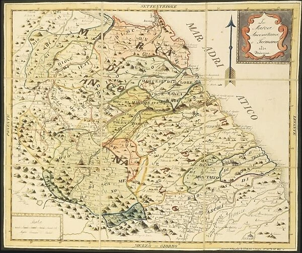
Map of Marca Anconetana and Fermana, Bologna, Italy, 1831
Filename: 940_18_11285179.jpg
Size: 5438 x 4556 (7.0MB)
Date: 12th March 2014
Source: Universal Images Group (UIG)
Source: De Agostini Picture Library
© DEA / G. DAGLI ORTI
![]()

Wall Art and Photo Gifts from Universal Images Group (UIG)
Map of Marca Anconetana and Fermana, Bologna, Italy, 1831
Cartography, Italy, 19th century. Map of Marca Anconetana and Fermana. Bologna. 1831
Universal Images Group (UIG) manages distribution for many leading specialist agencies worldwide
Media ID 9502011
© DEA / G. DAGLI ORTI
1831 Aerial View Ancona Arrow Sign Bologna Border Boundary Coastline Field Guidance Marches Navigational Equipment Text Western Script Fermo Non Urban Scene
EDITORS COMMENTS
This print showcases a remarkable piece of cartography from 19th century Italy. The "Map of Marca Anconetana and Fermana, Bologna, Italy, 1831" is a testament to the intricate artistry and meticulous attention to detail that went into creating maps during this era. The map itself depicts the boundary lines between Marca Anconetana and Fermana, two regions in Italy. With its horizontal orientation, it provides a comprehensive view of the topography and landscape of this area. The coastline stretches out majestically towards the sea, offering a glimpse into the historical significance of these territories. Navigational equipment such as arrow signs can be seen scattered throughout the map, serving as guidance for travelers exploring these lands. The use of Western script adds an element of familiarity to this historical artifact. As we gaze upon this non-urban scene captured through aerial perspective, we are transported back in time to witness a slice of history unfold before our eyes. This artwork beautifully combines illustration and painting techniques to create an exquisite representation of the past. With no people present in the image, our focus is solely on appreciating the craftsmanship behind this masterpiece. It serves as a reminder that even without commercial intentions or modern technology at their disposal, cartographers were able to create stunning works that continue to captivate us today.
MADE IN THE USA
Safe Shipping with 30 Day Money Back Guarantee
FREE PERSONALISATION*
We are proud to offer a range of customisation features including Personalised Captions, Color Filters and Picture Zoom Tools
SECURE PAYMENTS
We happily accept a wide range of payment options so you can pay for the things you need in the way that is most convenient for you
* Options may vary by product and licensing agreement. Zoomed Pictures can be adjusted in the Cart.


