Rights Managed > Universal Images Group (UIG) > Art > Painting, Sculpture & Prints > Cartography
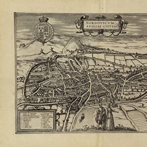
Map of Norwich from Civitates Orbis Terrarum by Georg Braun, 1541-1622 and Franz Hogenberg, 1540-1590, engraving

Filename: 940_18_11314590.jpg
Size: 5448 x 4223 (9.7MB)
Date: 12th March 2014
Source: Universal Images Group (UIG)
Source: De Agostini Picture Library
© DEA / R. MERLO
![]()
Wall Art and Photo Gifts from Universal Images Group (UIG)
Map of Norwich from Civitates Orbis Terrarum by Georg Braun, 1541-1622 and Franz Hogenberg, 1540-1590, engraving
Cartography, Great Britain, 16th century. Map of Norwich. From Civitates Orbis Terrarum by Georg Braun (1541-1622) and Franz Hogenberg (1540-1590), Cologne. Engraving
Universal Images Group (UIG) manages distribution for many leading specialist agencies worldwide
Media ID 9502783
© DEA / R. MERLO
16th Century Coat Of Arms Elevated View Latin Script Manuscript Norwich Rolling Landscape Townscape
EDITORS COMMENTS
This print showcases a remarkable piece of cartographic history - the Map of Norwich from Civitates Orbis Terrarum by Georg Braun and Franz Hogenberg. Created between 1541 and 1622, this engraving takes us back to the vibrant streets of Norwich in the 16th century. The intricate details captured in this studio shot reveal a townscape that is both enchanting and rich with historical significance. The rolling landscape depicted in the map's elevated view transports us to an era where physical geography played a vital role in shaping urban development. As we delve into this masterpiece, our eyes are drawn to the exquisite coat of arms proudly displayed at its center. This emblem symbolizes the city's identity and heritage, reminding us of its importance as a cultural hub during that time. The artistry behind this illustration and painting is truly awe-inspiring. Every stroke tells a story, every line represents meticulous craftsmanship. It serves as a testament to human representation through visual storytelling, even without any people present within its frame. Accompanied by Latin script, this map not only provides geographical information but also offers insight into how society perceived their surroundings centuries ago. Its presence evokes curiosity about Norwich's past while celebrating the beauty found within ancient cartography. This print from Universal Images Group (UIG) invites us on an immersive journey through time - an opportunity to explore history through art and discover hidden narratives embedded within landscapes long gone.
MADE IN THE USA
Safe Shipping with 30 Day Money Back Guarantee
FREE PERSONALISATION*
We are proud to offer a range of customisation features including Personalised Captions, Color Filters and Picture Zoom Tools
SECURE PAYMENTS
We happily accept a wide range of payment options so you can pay for the things you need in the way that is most convenient for you
* Options may vary by product and licensing agreement. Zoomed Pictures can be adjusted in the Cart.