Rights Managed > Universal Images Group (UIG) > Art > Painting, Sculpture & Prints > Cartography
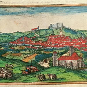
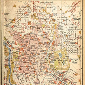
Map of San Sebastian and Burgos from Civitates Orbis Terrarum by Georg Braun, 1541-1622 and Franz Hogenberg, 1540-1590, engraving

Filename: 940_18_11314585.jpg
Size: 5240 x 4061 (10.3MB)
Date: 12th March 2014
Source: Universal Images Group (UIG)
Source: De Agostini Picture Library
© DEA / R. MERLO
![]()
Wall Art and Photo Gifts from Universal Images Group (UIG)
Map of San Sebastian and Burgos from Civitates Orbis Terrarum by Georg Braun, 1541-1622 and Franz Hogenberg, 1540-1590, engraving
Cartography, Spain, 16th century. Map of San Sebastian and Burgos. From Civitates Orbis Terrarum by Georg Braun (1541-1622) and Franz Hogenberg (1540-1590), Cologne. Engraving
Universal Images Group (UIG) manages distribution for many leading specialist agencies worldwide
Media ID 9501777
© DEA / R. MERLO
16th Century Elevated View Horizon Over Land Horizon Over Water Manuscript Peninsula Spain Burgos San Sebastian
EDITORS COMMENTS
This print showcases a remarkable piece of cartographic history - the Map of San Sebastian and Burgos from Civitates Orbis Terrarum by Georg Braun and Franz Hogenberg. Created in the 16th century, this engraving offers a fascinating glimpse into Spain's physical geography during that era. The map, meticulously crafted with intricate details, transports us back in time to explore the enchanting landscapes of San Sebastian and Burgos. With its horizontal layout, we are presented with an elevated view that allows us to marvel at the stunning peninsula where these cities reside. As we delve deeper into this studio shot, our eyes are drawn towards the mesmerizing bay and expansive sea surrounding these historic locations. The artist's skillful use of illustration and painting brings life to this manuscript-like depiction. Although devoid of human representation, this artful creation speaks volumes about Spain's rich history. It serves as a testament to the mastery of cartography during that period while also offering insights into how these cities were perceived centuries ago. With no commercial intentions behind it, this print invites us to appreciate its beauty purely for artistic appreciation. It reminds us of how maps can transcend their practical purpose and become works of art themselves - capturing not only geographical information but also cultural significance for generations to come.
MADE IN THE USA
Safe Shipping with 30 Day Money Back Guarantee
FREE PERSONALISATION*
We are proud to offer a range of customisation features including Personalised Captions, Color Filters and Picture Zoom Tools
SECURE PAYMENTS
We happily accept a wide range of payment options so you can pay for the things you need in the way that is most convenient for you
* Options may vary by product and licensing agreement. Zoomed Pictures can be adjusted in the Cart.