Rights Managed > Universal Images Group (UIG) > Art > Painting, Sculpture & Prints > Cartography
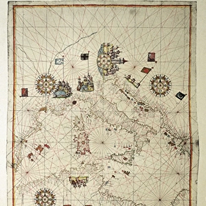
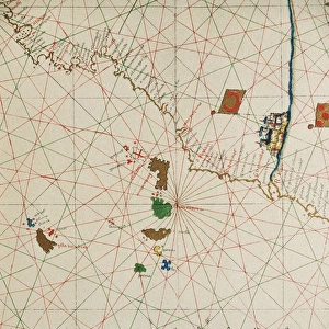
Portolan chart of Venice and Genoa

Filename: 940_18_11056286.jpg
Size: 3937 x 3136 (6.0MB)
Date: 12th March 2014
Source: Universal Images Group (UIG)
Source: De Agostini Picture Library
© DEA / A. DAGLI ORTI
![]()
Wall Art and Photo Gifts from Universal Images Group (UIG)
Portolan chart of Venice and Genoa
Cartography, Italy, 15th century. Portolan chart of Venice and Genoa
Universal Images Group (UIG) manages distribution for many leading specialist agencies worldwide
Media ID 9501115
© DEA / A. DAGLI ORTI
15th Century Genoa Italian Culture Liguria Port Veneto Venice Western Script Portolan Chart
EDITORS COMMENTS
This stunning print showcases a remarkable piece of cartographic history - a Portolan chart of Venice and Genoa, dating back to the 15th century. The intricate details and exquisite craftsmanship captured in this studio shot transport us back in time, offering a glimpse into the rich heritage of Italy's maritime past. The chart itself is a true work of art, meticulously hand-drawn with Western script and featuring the distinctive architecture of both Venice and Genoa. Its horizontal layout allows for easy navigation across the vast expanse of water that separates these two iconic port cities. As we study this ancient map, we are reminded not only of its practical purpose as a navigational tool but also its cultural significance. It serves as a testament to the ingenuity and skill possessed by Italian cartographers during this period. The absence of people in this image invites us to focus solely on the beauty and complexity inherent in this historical artifact. Each stroke tells a story, each line represents countless hours spent perfecting every detail. Through this print from Universal Images Group (UIG), we can appreciate how physical geography was intricately intertwined with artistry during those times. This visual treasure transports us to an era where maps were not merely utilitarian objects but rather expressions of creativity fused with scientific knowledge – truly capturing the essence of Italian culture at its finest.
MADE IN THE USA
Safe Shipping with 30 Day Money Back Guarantee
FREE PERSONALISATION*
We are proud to offer a range of customisation features including Personalised Captions, Color Filters and Picture Zoom Tools
SECURE PAYMENTS
We happily accept a wide range of payment options so you can pay for the things you need in the way that is most convenient for you
* Options may vary by product and licensing agreement. Zoomed Pictures can be adjusted in the Cart.