Rights Managed > Universal Images Group (UIG) > Art > Painting, Sculpture & Prints > Cartography
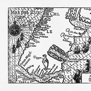
Tabula Orbis cum Descriptione Ventorum, by Gaspar Treschel, colored engraving, 1522

Filename: 940_18_11461883.jpg
Size: 5746 x 4361 (25.0MB)
Date: 16th March 2014
Source: Universal Images Group (UIG)
Source: De Agostini Picture Library
© DEA PICTURE LIBRARY
![]()
Wall Art and Photo Gifts from Universal Images Group (UIG)
Tabula Orbis cum Descriptione Ventorum, by Gaspar Treschel, colored engraving, 1522
Cartography, 16th century. Tabula Orbis Cum Descriptione Ventorum, by Gaspar Treschel, 1522. Colored engraving
Universal Images Group (UIG) manages distribution for many leading specialist agencies worldwide
Media ID 9571199
© DEA PICTURE LIBRARY
16th Century Crossing Direction Guidance Western Script World Map
EDITORS COMMENTS
This print showcases the exquisite "Tabula Orbis cum Descriptione Ventorum" by Gaspar Treschel, a colored engraving from 1522. Stepping back in time to the 16th century, this piece of cartography is a true testament to the artistry and precision of early mapmaking. Intricately detailed, this horizontal world map takes us on a visual journey through history. The vibrant colors bring life to the various continents and oceans depicted, while Western script labels provide guidance for travelers seeking new horizons. This engraving not only serves as a navigational tool but also offers insights into physical geography during that era. The absence of people in this artwork allows us to focus solely on its beauty and historical significance. It reminds us of how far we have come in terms of exploration and understanding our planet's vastness. As an illustration and painting, this print captures both artistic finesse and scientific accuracy. Its presence invites contemplation about the challenges faced by early explorers who relied heavily on maps like these for their journeys across unknown territories. Displaying this remarkable piece would be an excellent addition to any space that appreciates history, travel, or artistry. Whether you are fascinated by cartography or simply drawn to its aesthetic appeal, this print transports you back in time while celebrating human curiosity and our unending quest for knowledge about the world around us.
MADE IN THE UK
Safe Shipping with 30 Day Money Back Guarantee
FREE PERSONALISATION*
We are proud to offer a range of customisation features including Personalised Captions, Color Filters and Picture Zoom Tools
SECURE PAYMENTS
We happily accept a wide range of payment options so you can pay for the things you need in the way that is most convenient for you
* Options may vary by product and licensing agreement. Zoomed Pictures can be adjusted in the Basket.