Rights Managed > Universal Images Group (UIG) > Illustrations > Illustrations 2
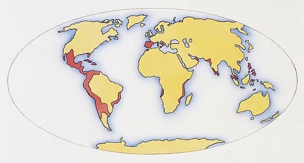
World map, red areas highlighting extent of Spanish and Portuguese Empires in 1588
Filename: 955_28_167994.jpg
Size: 5790 x 3105 (14.5MB)
Date: 15th March 2014
Source: Universal Images Group (UIG)
Country: Unspecified
© Dorling Kindersley/UIG
![]()

Wall Art and Photo Gifts from Universal Images Group (UIG)
World map, red areas highlighting extent of Spanish and Portuguese Empires in 1588
Universal Images Group (UIG) manages distribution for many leading specialist agencies worldwide
Media ID 9541311
© Dorling Kindersley/UIG
16th Century Colonies Commerce Conquest Globe Military History Planet Spain Trade World Map Globalisation Globalization
EDITORS COMMENTS
This print from Universal Images Group (UIG) showcases a world map dating back to 1588, meticulously illustrating the vast extent of the Spanish and Portuguese Empires during that era. The vibrant red areas boldly highlight the territories conquered by these two powerful nations, offering a glimpse into their dominance and influence on a global scale. Intriguingly, this image not only represents land conquest but also symbolizes an era of immense exploration, colonization, and trade. It serves as a visual testament to the ambition and determination of Spain and Portugal in expanding their empires across continents. From South America to Africa to Asia, these red areas signify regions where Spanish and Portuguese flags flew high amidst bustling colonies engaged in commerce. Beyond its historical significance, this illustration offers insights into military history as well as economic globalization during the 16th century. It reminds us of how different parts of our planet were interconnected even centuries ago through conquests and trade routes established by these European powers. As we gaze upon this remarkable depiction of our Earth's past, it prompts us to reflect on the impact such empires had on shaping our present-day world. This photograph is not merely an artistic representation; it encapsulates an entire epoch defined by territorial expansionism, cultural exchange, and commercial endeavors that continue to shape our understanding of global history today.
MADE IN THE USA
Safe Shipping with 30 Day Money Back Guarantee
FREE PERSONALISATION*
We are proud to offer a range of customisation features including Personalised Captions, Color Filters and Picture Zoom Tools
SECURE PAYMENTS
We happily accept a wide range of payment options so you can pay for the things you need in the way that is most convenient for you
* Options may vary by product and licensing agreement. Zoomed Pictures can be adjusted in the Cart.

