Rights Managed > WorldInPrint
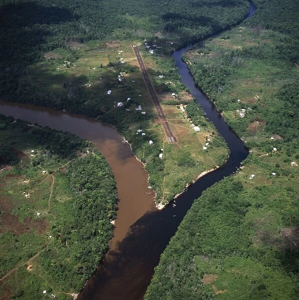
Aerial image of Kamarang Mouth Station and airstrip at the confluence of the unpolluted Kamarang River with the mined and heavily polluted Upper Mazaruni River in March 2005, Guyana
Filename: 823-290.jpg
Size: 5102 x 5120 (9.5MB)
Date: 2nd March 2010
Source: WorldInPrint
Credit: Last Refuge/Robert Harding
Copyright Status: Copyrighted Work
Owner URL: www.robertharding.comwww.ardea.com
Country: Guyana
© Last Refuge
![]()

Wall Art and Photo Gifts from Robert Harding
Aerial image of Kamarang Mouth Station and airstrip at the confluence of the unpolluted Kamarang River with the mined and heavily polluted Upper Mazaruni River in March 2005, Guyana
Aerial image of Kamarang Mouth Station and airstrip at the confluence of the unpolluted Kamarang River with the mined and heavily polluted Upper Mazaruni River in March 2005, Guyana, South America
Robert Harding Picture Library provides high quality travel, nature, wildlife & environmental photos
Media ID 3756292
© Last Refuge
Air Port Confluence Guyana Land Pollution Square Image View From Above Air Strip Airport Runway Mazaruni Polluted Runway Unpolluted
EDITORS COMMENTS
This aerial image showcases the striking contrast between two rivers in Guyana, South America. Taken in March 2005 by Last Refuge/Robert Harding, the photograph captures the confluence of the unpolluted Kamarang River with the heavily polluted Upper Mazaruni River. The view from above reveals a stunning landscape that tells a tale of environmental degradation and untouched beauty. In this photo print, one can see the pristine blue waters of the Kamarang River flowing gracefully into the murky and contaminated Upper Mazaruni River. The stark difference between these two bodies of water is a powerful reminder of human impact on nature. As mining activities have taken place along the Upper Mazaruni River, pollution has seeped into its once clear waters. The image also features an airstrip at Kamarang Mouth Station, adding to its scenic appeal. The airport runway stands as a symbol of connection and travel amidst this contrasting environment. With no people visible in this high-angle view, it allows viewers to focus solely on nature's resilience against man-made pollution. This square-shaped photograph offers an immersive experience for those who appreciate both photography and environmental conservation. WorldInPrint presents this remarkable aerial view as part of their collection that celebrates travel destinations and natural wonders worldwide. It serves as a poignant reminder to protect our planet's precious resources while exploring its breathtaking landscapes.
MADE IN THE USA
Safe Shipping with 30 Day Money Back Guarantee
FREE PERSONALISATION*
We are proud to offer a range of customisation features including Personalised Captions, Color Filters and Picture Zoom Tools
SECURE PAYMENTS
We happily accept a wide range of payment options so you can pay for the things you need in the way that is most convenient for you
* Options may vary by product and licensing agreement. Zoomed Pictures can be adjusted in the Cart.


