Home > Arts > Artists > Leonardo da Vinci > Sketches and drawings by Leonardo da
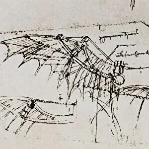
Chorographical map of the Val di Chiana, Lake Trasimeno and the neighboring regions, including a large part of the region of Siena, drawing (12278r), by Leonardo da Vinci, housed in the Royal Library of Windsor
, by Leonardo da Vinci, housed in the Royal Library of Windsor")
![]()
Wall Art and Photo Gifts from Fondazione Alinari per la Fotografia
Chorographical map of the Val di Chiana, Lake Trasimeno and the neighboring regions, including a large part of the region of Siena, drawing (12278r), by Leonardo da Vinci, housed in the Royal Library of Windsor
Chorographical map of the Val di Chiana, Lake Trasimeno and the neighboring regions, including a large part of the region of Siena, drawing (12278r), by Leonardo da Vinci, housed in the Royal Library of Windsor Drawing High Renaissance, Renaissance, Renaissance-Baroque styles and periods, Europe, First and Second Millennium A.D.. Date of Photograph:2001. Date of Artwork:1478-1518 ca.. Artist:Leonardo da Vinci (1452-1519)
PDP-S-000GEO-0012
Media ID 33187851
© Alinari Archives, Florence
Geographical Or Topographical Map Geography Instrument And Document Maphigh Renaissance Landscape Mountains
FEATURES IN THESE COLLECTIONS
> Arts
> Art Movements
> Baroque
> Arts
> Art Movements
> Renaissance Art
> Arts
> Artists
> Leonardo da Vinci
> Renaissance art
> Arts
> Artists
> Leonardo da Vinci
> Sketches and drawings by Leonardo da
> Arts
> Artists
> Leonardo da Vinci
> Arts
> Artists
> Leonardo Da Vinci
> Arts
> Artists
> V
> Leonardo da Vinci
> Arts
> Contemporary art
> Landscapes
> Mountain landscapes
> Arts
> Landscape paintings
> Landscape art
> Mountain landscapes
EDITORS COMMENTS
This print showcases the remarkable "Chorographical map of the Val di Chiana, Lake Trasimeno and the neighboring regions, including a large part of the region of Siena" drawn by none other than Leonardo da Vinci himself. Housed in the prestigious Royal Library of Windsor, this drawing exemplifies Da Vinci's mastery in various artistic styles and periods such as High Renaissance, Renaissance-Baroque. Created between 1478-1518 approximately, this artwork is a testament to Da Vinci's multifaceted genius. The intricately detailed map offers a glimpse into Europe during the First and Second Millennium A. D. , providing invaluable insights into geographical and topographical aspects of that era. With mountains majestically depicted in its landscape, this piece not only serves as an instrument for navigation but also stands as a significant historical document. The photograph was taken in 2001 with utmost precision to capture every minute detail present on this masterpiece. It allows viewers to appreciate Da Vinci's meticulous craftsmanship up close while preserving its essence for future generations. Leonardo da Vinci (1452-1519), renowned as one of history's greatest polymaths, left an indelible mark on art and science alike. This particular work highlights his profound understanding of geography and landscape portrayal. Through his unique blend of scientific observation and artistic finesse, he transcended boundaries between disciplines like no other artist before him. As we delve into this extraordinary image captured by Alinari without any commercial intent or affiliation mentioned here let us marvel at how one man could encapsulate so much knowledge within a single creation. Leonardo da Vinci continues to inspire awe centuries later through his timeless contributions to humanity's cultural heritage.
MADE IN THE USA
Safe Shipping with 30 Day Money Back Guarantee
FREE PERSONALISATION*
We are proud to offer a range of customisation features including Personalised Captions, Color Filters and Picture Zoom Tools
SECURE PAYMENTS
We happily accept a wide range of payment options so you can pay for the things you need in the way that is most convenient for you
* Options may vary by product and licensing agreement. Zoomed Pictures can be adjusted in the Cart.