Canvas Print > Oceania > Australia > Maps
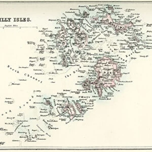
Canvas Print : Map of Melbourne and Port Phillip, Australia, 19th Century


![]()
Canvas Prints from Australian Views
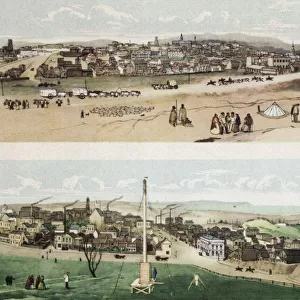
Map of Melbourne and Port Phillip, Australia, 19th Century
Vintage engraving of Map of Melbourne and Port Phillip, Australia, 19th Century
Unveiling the Splendour of Australia through Exquisite Artwork
duncan1890
1130796496
Media ID 28761191
© of Duncan P Walker
1880 1889 19th Century Antique Archival Black And White Cartography Engraving Equipment History Illustration Melbourne Australia Oceania Old Fashioned Styles The Past Victorian Style Woodcut Graphic Print Navigational Equipment Retro Style Victoria Australia
20"x16" (51x41cm) Canvas Print
Step back in time with our exquisite Canvas Print of "Map of Melbourne and Port Phillip, Australia, 19th Century" by duncan1890 from Australian Views. This vintage engraving transports you to a bygone era with intricate details and authentic charm. The high-quality canvas print faithfully reproduces the original map, capturing the historical significance of Melbourne and Port Phillip in Australia during the 19th century. Hang it in your home or office to add a touch of vintage elegance and rich history to your space.
Delivered stretched and ready to hang our premium quality canvas prints are made from a polyester/cotton blend canvas and stretched over a 1.25" (32mm) kiln dried knot free wood stretcher bar. Packaged in a plastic bag and secured to a cardboard insert for safe transit.
Canvas Prints add colour, depth and texture to any space. Professionally Stretched Canvas over a hidden Wooden Box Frame and Ready to Hang
Estimated Product Size is 40.6cm x 50.8cm (16" x 20")
These are individually made so all sizes are approximate
Artwork printed orientated as per the preview above, with portrait (vertical) orientation to match the source image.
FEATURES IN THESE COLLECTIONS
> Australian Views
> Australia's Rich History
> Historic
> Historical fashion trends
> Victorian fashion trends
> Historic
> Victorian era fashion
> Maps and Charts
> Related Images
> Oceania
> Australia
> Melbourne
> Oceania
> Australia
> Related Images
EDITORS COMMENTS
This vintage engraving of the Map of Melbourne and Port Phillip, Australia takes us back to the 19th century, offering a glimpse into the rich history and development of this vibrant city. The black and white woodcut illustration showcases intricate cartography skills that were prevalent during that era. The map itself is a testament to the navigational equipment used at the time, highlighting how seafarers relied on such detailed illustrations for safe passage. It serves as an archival piece, capturing a snapshot of Melbourne's past in its old-fashioned retro style. As we delve into this graphic print, we are transported to Victorian-era Australia. The meticulous attention to detail reveals various styles employed by cartographers during this period. This particular map was created between 1880-1889, making it an invaluable historical artifact. Melbourne's prominence as a major city in Victoria is evident through its depiction on this map. Every street corner and landmark is meticulously outlined, providing insight into how urban planning evolved over time. Duncan1890 has skillfully captured the essence of Melbourne's heritage with this antique print. Whether you're an avid historian or simply appreciate artistry from days gone by, this image offers a fascinating window into Australia's past.
MADE IN THE USA
Safe Shipping with 30 Day Money Back Guarantee
FREE PERSONALISATION*
We are proud to offer a range of customisation features including Personalised Captions, Color Filters and Picture Zoom Tools
SECURE PAYMENTS
We happily accept a wide range of payment options so you can pay for the things you need in the way that is most convenient for you
* Options may vary by product and licensing agreement. Zoomed Pictures can be adjusted in the Cart.