Canvas Print > Europe > Macedonia > Maps
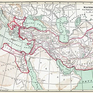
Canvas Print : Map of Macedonia and adjacent districts. From Cassells Universal History, published 1888


![]()
Canvas Prints from Design Pics
Map of Macedonia and adjacent districts. From Cassells Universal History, published 1888
Design Pics offers Distinctively Different Imagery representing over 1,500 contributors
Media ID 24907168
© Ken Welsh
Adjacent Geographical Geography Macedon Macedonia Districts
30"x20" (76x51cm) Canvas Print
Step back in time with our vintage Map of Macedonia and adjacent districts, taken from the esteemed pages of Cassells Universal History, published in 1888. This captivating Canvas Print by Ken Welsh from Design Pics brings history to life with its intricate details and authentic antique look. Ideal for history enthusiasts, world travelers, or anyone looking to add a touch of classic charm to their decor. Order now and let this beautiful piece tell a story in your home or office.
Delivered stretched and ready to hang our premium quality canvas prints are made from a polyester/cotton blend canvas and stretched over a 1.25" (32mm) kiln dried knot free wood stretcher bar. Packaged in a plastic bag and secured to a cardboard insert for safe transit.
Canvas Prints add colour, depth and texture to any space. Professionally Stretched Canvas over a hidden Wooden Box Frame and Ready to Hang
Estimated Product Size is 76.2cm x 50.8cm (30" x 20")
These are individually made so all sizes are approximate
Artwork printed orientated as per the preview above, with landscape (horizontal) orientation to match the source image.
FEATURES IN THESE COLLECTIONS
> Europe
> Macedonia
> Posters
> Europe
> Macedonia
> Related Images
> Maps and Charts
> Early Maps
> Maps and Charts
> North Macedonia
> Maps and Charts
> Related Images
EDITORS COMMENTS
This vintage print showcases a remarkable "Map of Macedonia and adjacent districts" from the renowned Cassells Universal History, published in 1888. A true gem for history enthusiasts and geography aficionados alike, this archival engraving offers a glimpse into the past, transporting us to an era where cartography was meticulously crafted by skilled hands. The map depicts the intricate details of Macedonia's geographical landscape, capturing its neighboring regions with precision. Each district is intricately labeled, allowing viewers to immerse themselves in the historical context of this fascinating country. From its ancient roots as Macedon to its adjacent territories, this illustration provides a comprehensive overview of Macedonia's rich heritage. Ken Welsh's expertise shines through in his meticulous preservation of this period piece. The delicate lines and intricate engravings evoke a sense of nostalgia while reminding us of the importance that maps held in documenting our world's history. As we gaze upon this picture from yesteryears, we are reminded that every inch on this map carries stories untold – tales woven by generations who once called these lands home. It serves as a testament to human curiosity and exploration throughout time. Whether displayed as an educational tool or cherished as part of an antique collection, Ken Welsh’s timeless print invites us to embark on a journey through time and space – unraveling the mysteries locked within each contour line and boundary drawn on this Map of Macedonia and adjacent districts.
MADE IN THE USA
Safe Shipping with 30 Day Money Back Guarantee
FREE PERSONALISATION*
We are proud to offer a range of customisation features including Personalised Captions, Color Filters and Picture Zoom Tools
SECURE PAYMENTS
We happily accept a wide range of payment options so you can pay for the things you need in the way that is most convenient for you
* Options may vary by product and licensing agreement. Zoomed Pictures can be adjusted in the Cart.