Canvas Print > North America > Nicaragua > Lakes > Lake Nicaragua
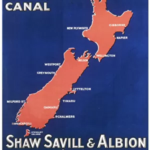
Canvas Print : Map showing the Nicaraguan Canal, a proposed shipping route through Nicaragua via Lake Nicaragua in the first decade of the 20th century, which would have connected the Atlantic and the Pacific Oceans. The plan never went ahead after the building of the Panama canal. From The Business Encyclopaedia and Legal Adviser, published 1907


![]()
Canvas Prints from Design Pics
Map showing the Nicaraguan Canal, a proposed shipping route through Nicaragua via Lake Nicaragua in the first decade of the 20th century, which would have connected the Atlantic and the Pacific Oceans. The plan never went ahead after the building of the Panama canal. From The Business Encyclopaedia and Legal Adviser, published 1907
Design Pics offers Distinctively Different Imagery representing over 1,500 contributors
Media ID 24906353
© Ken Welsh
20th Century Atlantic Ocean Canals Central America Central American Connected Connection Man Made Pacific Ocean Plan Waterway Waterways Lake Nicaragua Nicaragua Proposed Shipping Route
30"x20" (76x51cm) Canvas Print
Delivered stretched and ready to hang our premium quality canvas prints are made from a polyester/cotton blend canvas and stretched over a 1.25" (32mm) kiln dried knot free wood stretcher bar. Packaged in a plastic bag and secured to a cardboard insert for safe transit.
Canvas Prints add colour, depth and texture to any space. Professionally Stretched Canvas over a hidden Wooden Box Frame and Ready to Hang
Estimated Product Size is 76.2cm x 50.8cm (30" x 20")
These are individually made so all sizes are approximate
Artwork printed orientated as per the preview above, with landscape (horizontal) orientation to match the source image.
FEATURES IN THESE COLLECTIONS
> Maps and Charts
> Early Maps
> North America
> Nicaragua
> Lakes
> Lake Nicaragua
> North America
> Nicaragua
> Lakes
> Related Images
> North America
> Nicaragua
> Maps
> North America
> Nicaragua
> Related Images
> North America
> Panama
> Lakes
> Related Images
> North America
> Panama
> Maps
> North America
> Panama
> Related Images
MADE IN THE USA
Safe Shipping with 30 Day Money Back Guarantee
FREE PERSONALISATION*
We are proud to offer a range of customisation features including Personalised Captions, Color Filters and Picture Zoom Tools
SECURE PAYMENTS
We happily accept a wide range of payment options so you can pay for the things you need in the way that is most convenient for you
* Options may vary by product and licensing agreement. Zoomed Pictures can be adjusted in the Cart.