Canvas Print > Europe > Moldova > Maps
Canvas Print : Map of Romania 1683


![]()
Canvas Prints from Fine Art Finder
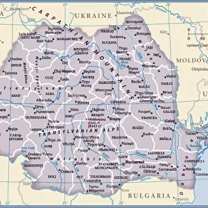
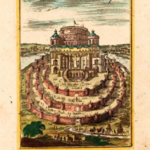
Map of Romania 1683
7143246 Map of Romania 1683 by Mallet, Alain Manesson (1630-1706); Private Collection; (add.info.: Geography. Romania. Map of Moldavia and Transylvania. Engraving in: Description de l Univers, by Alain Manesson Mallet, France, 1683.); Photo: eArchives Charmet; French, out of copyright
Media ID 24128098
© Photo: Archives Charmet / Bridgeman Images
Moldavia Moldova Moldovan Romania Roumania Geographical Map
30"x20" (76x51cm) Canvas Print
Bring history to life with our exquisite Canvas Prints from Media Storehouse. This particular piece showcases the captivating Map of Romania from 1683, an intriguing representation of Moldavia and Transylvania by Alain Manesson Mallet. With stunning detail and vibrant colors, our high-quality canvas prints capture the essence of this Fine Art Finder image from Bridgeman Images. Each print is carefully crafted to provide a museum-quality finish, ensuring your map of Romania becomes a beautiful and conversation-starting addition to your home or office decor.
Delivered stretched and ready to hang our premium quality canvas prints are made from a polyester/cotton blend canvas and stretched over a 1.25" (32mm) kiln dried knot free wood stretcher bar. Packaged in a plastic bag and secured to a cardboard insert for safe transit.
Canvas Prints add colour, depth and texture to any space. Professionally Stretched Canvas over a hidden Wooden Box Frame and Ready to Hang
Estimated Product Size is 50.8cm x 76.2cm (20" x 30")
These are individually made so all sizes are approximate
Artwork printed orientated as per the preview above, with portrait (vertical) orientation to match the source image.
FEATURES IN THESE COLLECTIONS
> Europe
> Moldova
> Related Images
> Europe
> Romania
> Related Images
> Maps and Charts
> Related Images
> Fine Art Finder
> Artists
> Alain Manesson Mallet
EDITORS COMMENTS
This print showcases a stunning map of Romania from the year 1683. Created by Alain Manesson Mallet, a renowned French cartographer, this engraving is part of his remarkable work titled "Description de l'Univers". The map provides an intricate depiction of Moldavia and Transylvania, two regions that were integral to Romania's history. The level of detail in this 17th-century masterpiece is truly awe-inspiring. Every contour and boundary line has been meticulously etched onto the paper, revealing the geographical intricacies of the land. As you explore this enchanting map, you can almost feel yourself being transported back in time to an era when cartography was both an art form and a scientific endeavor. Romania's rich cultural heritage comes alive through this historical representation. From Moldova to Transylvania, every region is highlighted with precision and accuracy. This visual treasure not only serves as a testament to Mallet's skill as an engraver but also offers valuable insights into Europe's past. As you gaze upon this extraordinary piece, take a moment to appreciate how it encapsulates centuries worth of knowledge and exploration. It reminds us that maps are not just tools for navigation; they are windows into our collective history and identity. Bridgeman Images has once again provided us with access to a rare gem from their private collection. Through their lens, we can delve into the wonders of Romanian geography while marveling at the craftsmanship behind this exquisite engraving.
MADE IN THE USA
Safe Shipping with 30 Day Money Back Guarantee
FREE PERSONALISATION*
We are proud to offer a range of customisation features including Personalised Captions, Color Filters and Picture Zoom Tools
SECURE PAYMENTS
We happily accept a wide range of payment options so you can pay for the things you need in the way that is most convenient for you
* Options may vary by product and licensing agreement. Zoomed Pictures can be adjusted in the Cart.