Canvas Print > Europe > France > Canton > Landes
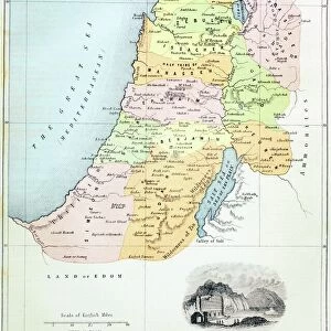
Canvas Print : Map of the Holy Land (coloured engraving)
")
")


![]()
Canvas Prints from Fine Art Finder
Map of the Holy Land (coloured engraving)
VNK249240 Map of the Holy Land (coloured engraving) by Danckerts, Theodorus (1663-1727); Vorontsov Palace, Crimea, Ukraine; (add.info.: carte de la Judee, dite aussi la Terre Sainte; ); eVadim Nekrasov; Dutch, out of copyright
Media ID 23203846
© Vadim Nekrasov / Bridgeman Images
Dead Sea Galilee Israel Judea Mediterranean Samaria
20"x16" (51x41cm) Canvas Print
Bring the rich history of the Holy Land into your home with our stunning Canvas Print of the Map of the Holy Land by Vadim Nekrasov. This beautiful coloured engraving, originally created by Theodorus Danckerts in 1663, is a captivating representation of the region's historical significance. Meticulously reproduced on high-quality canvas, this artwork adds an elegant and educational touch to any room. Discover the intricate details of the map, which includes the Vorontsov Palace in Crimea, Ukraine, as an added point of interest. Elevate your decor and transport yourself to another time and place with this exquisite Canvas Print.
Delivered stretched and ready to hang our premium quality canvas prints are made from a polyester/cotton blend canvas and stretched over a 1.25" (32mm) kiln dried knot free wood stretcher bar. Packaged in a plastic bag and secured to a cardboard insert for safe transit.
Canvas Prints add colour, depth and texture to any space. Professionally Stretched Canvas over a hidden Wooden Box Frame and Ready to Hang
Estimated Product Size is 50.8cm x 40.6cm (20" x 16")
These are individually made so all sizes are approximate
Artwork printed orientated as per the preview above, with landscape (horizontal) orientation to match the source image.
FEATURES IN THESE COLLECTIONS
> Asia
> Israel
> Related Images
> Europe
> France
> Canton
> Landes
> Europe
> Ukraine
> Related Images
> Maps and Charts
> Related Images
> Fine Art Finder
> Artists
> Antoine Charles Horace (1758-1836)
> Fine Art Finder
> Maps (celestial & Terrestrial)
EDITORS COMMENTS
This print showcases a beautifully colored engraving of the Map of the Holy Land. Created by the talented artist Danckerts, Theodorus in 1663-1727, this masterpiece is now housed in the Vorontsov Palace located in Crimea, Ukraine. The intricate details and vibrant hues bring to life this historic map depicting Judea, also known as the Terre Sainte or Holy Land. From the mesmerizing Dead Sea to the serene Galilee and Mediterranean regions, every corner of this sacred land is meticulously illustrated. As you gaze upon this print, you can almost feel yourself transported back in time to ancient Israel. The engraving skillfully captures not only geographical features but also significant biblical sites such as Judea and Samaria. The craftsmanship exhibited in this artwork is truly remarkable; it serves as a testament to Dutch artistry during that era. With its rich history and cultural significance, it's no wonder that Vadim Nekrasov chose to immortalize this piece through his lens. Whether you are an art enthusiast or simply intrigued by historical maps, this print will undoubtedly captivate your imagination. It offers a unique glimpse into both past and present landscapes while honoring centuries-old traditions associated with faith and spirituality.
MADE IN THE USA
Safe Shipping with 30 Day Money Back Guarantee
FREE PERSONALISATION*
We are proud to offer a range of customisation features including Personalised Captions, Color Filters and Picture Zoom Tools
SECURE PAYMENTS
We happily accept a wide range of payment options so you can pay for the things you need in the way that is most convenient for you
* Options may vary by product and licensing agreement. Zoomed Pictures can be adjusted in the Cart.