Canvas Print > Europe > United Kingdom > Scotland > Moray > Keith
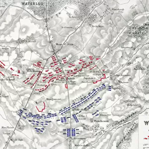
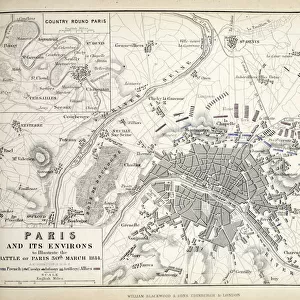
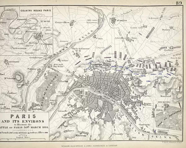
Canvas Print : Paris and its Environs, to illustrate the Battle of Paris, 30th March, 1814


![]()
Canvas Prints from Fine Art Finder
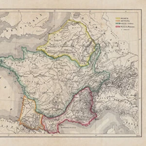
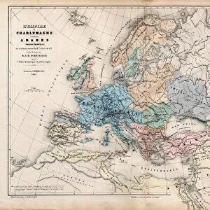
Paris and its Environs, to illustrate the Battle of Paris, 30th March, 1814
617389 Paris and its Environs, to illustrate the Battle of Paris, 30th March, 1814, published c.1830s (engraving) by Johnston, Alexander Keith (1804-71); Private Collection; Scottish, out of copyright
Media ID 22617360
© Bridgeman Images
Aerial Defeat Napoleon Napoleonic Wars
20"x16" (51x41cm) Canvas Print
Bring the historic Battle of Paris to life in your home with our stunning Canvas Prints from Media Storehouse. This captivating artwork, titled "Paris and its Environs, to illustrate the Battle of Paris, 30th March, 1814," is a rare and intriguing engraving by Alexander Keith Johnston, published in the 1830s. Witness the iconic city of Paris as it was depicted during this pivotal moment in history, as Napoleon Bonaparte's forces retreated from the advancing Allied armies. Add an element of history and elegance to your decor with this beautiful and authentic piece, expertly printed on high-quality canvas for a vibrant and detailed finish. Experience the past like never before with Media Storehouse's Canvas Prints.
Delivered stretched and ready to hang our premium quality canvas prints are made from a polyester/cotton blend canvas and stretched over a 1.25" (32mm) kiln dried knot free wood stretcher bar. Packaged in a plastic bag and secured to a cardboard insert for safe transit.
Canvas Prints add colour, depth and texture to any space. Professionally Stretched Canvas over a hidden Wooden Box Frame and Ready to Hang
Estimated Product Size is 50.8cm x 40.6cm (20" x 16")
These are individually made so all sizes are approximate
Artwork printed orientated as per the preview above, with landscape (horizontal) orientation to match the source image.
FEATURES IN THESE COLLECTIONS
> Aerial Photography
> Related Images
> Aerial Photography
> Scotland
> Europe
> France
> Paris
> Maps
> Europe
> United Kingdom
> Scotland
> Aerial Views
> Europe
> United Kingdom
> Scotland
> Maps
> Europe
> United Kingdom
> Scotland
> Moray
> Keith
> Europe
> United Kingdom
> Scotland
> Posters
> Europe
> United Kingdom
> Scotland
> Related Images
> Historic
> Battles
> Related Images
> Maps and Charts
> Related Images
> Fine Art Finder
> Artists
> Alexander Keith Johnston
> Fine Art Finder
> Artists
> Arthur Melville
> Fine Art Finder
> Maps (celestial & Terrestrial)
EDITORS COMMENTS
This engraving, titled "Paris and its Environs, to illustrate the Battle of Paris, 30th March, 1814" takes us back in time to a significant moment in history. Published in the 1830s by Alexander Keith Johnston, this print offers a unique perspective on the city of Paris during one of its most tumultuous periods. The image showcases an aerial view of Paris and its surrounding areas, providing a detailed map-like representation. However, it is not just a mere geographical depiction; it serves as a visual narrative for the Battle of Paris that took place on March 30th, 1814. This battle marked a pivotal moment in the Napoleonic Wars and ultimately led to Napoleon's defeat. As we gaze upon this historical artwork from Bridgeman Images' private collection, we are transported into an era filled with conflict and turmoil. The intricate details allow us to imagine the chaos that unfolded within these streets as armies clashed and power shifted hands. Beyond being visually striking, this engraving serves as both an educational tool and a reminder of humanity's capacity for resilience amidst adversity. It encapsulates not only the physical landscape but also captures the spirit of determination exhibited by those who fought for their beliefs. Through this print's lens, we gain insight into how wars shape cities like Paris – leaving indelible marks on their landscapes while shaping their future trajectories.
MADE IN THE USA
Safe Shipping with 30 Day Money Back Guarantee
FREE PERSONALISATION*
We are proud to offer a range of customisation features including Personalised Captions, Color Filters and Picture Zoom Tools
SECURE PAYMENTS
We happily accept a wide range of payment options so you can pay for the things you need in the way that is most convenient for you
* Options may vary by product and licensing agreement. Zoomed Pictures can be adjusted in the Cart.