Canvas Print > Arts > Artists > J > John June
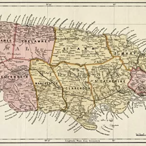
Canvas Print : Map of the Island of Jamaica (engraving)
")
")


![]()
Canvas Prints from Fine Art Finder
Map of the Island of Jamaica (engraving)
1099228 Map of the Island of Jamaica (engraving) by Dower, John (fl.c.1845-55); Private Collection; (add.info.: Map of the Island of Jamaica. Illustration for The Illustrated London News, 23 June 1866.); Look and Learn / Illustrated Papers Collection; English, out of copyright
Media ID 22513988
© Look and Learn / Illustrated Papers Collection / Bridgeman Images
30"x20" (76x51cm) Canvas Print
Bring the rich history of Jamaica into your home with our exquisite Canvas Print of the Map of the Island of Jamaica by John Dower. This stunning engraving, sourced from Bridgeman Images through Fine Art Finder, showcases intricate details of the island's geography from the mid-19th century. Each Canvas Print is meticulously crafted with premium materials, ensuring vibrant colors and sharp details that bring the map to life. Add a touch of history and culture to your decor with this beautiful and unique piece.
Delivered stretched and ready to hang our premium quality canvas prints are made from a polyester/cotton blend canvas and stretched over a 1.25" (32mm) kiln dried knot free wood stretcher bar. Packaged in a plastic bag and secured to a cardboard insert for safe transit.
Canvas Prints add colour, depth and texture to any space. Professionally Stretched Canvas over a hidden Wooden Box Frame and Ready to Hang
Estimated Product Size is 76.2cm x 50.8cm (30" x 20")
These are individually made so all sizes are approximate
Artwork printed orientated as per the preview above, with landscape (horizontal) orientation to match the source image.
FEATURES IN THESE COLLECTIONS
> Arts
> Artists
> J
> John June
> Maps and Charts
> Related Images
> North America
> Jamaica
> Maps
> North America
> Jamaica
> Related Images
> Fine Art Finder
> Artists
> English School
> Fine Art Finder
> Artists
> John Dower
> Fine Art Finder
> Temp Classification
EDITORS COMMENTS
This print showcases a remarkable engraving titled "Map of the Island of Jamaica" by John Dower, a talented artist who flourished between 1845 and 1855. The map, now part of a private collection, offers an intriguing glimpse into the past as it was featured in The Illustrated London News on June 23,1866. The intricate details and precision with which Dower created this map are truly awe-inspiring. Every contour and coastline is meticulously etched onto the surface, allowing viewers to explore the enchanting island of Jamaica from afar. As we gaze upon this historical artifact, we can almost feel ourselves transported back in time to an era when cartography was both artistry and science. Jamaica's natural beauty is brought to life through this engraving - its lush green mountains majestically rising above crystal-clear waters that surround the island's shores. This image not only serves as a visual representation but also evokes curiosity about what lies beyond those coastlines: hidden coves waiting to be discovered or vibrant towns bustling with activity. As we delve deeper into this artwork, it becomes apparent that it holds immense historical significance. It provides us with insights into how people perceived and understood geography during the mid-19th century. Moreover, it reminds us of Jamaica's rich cultural heritage and its place within the Caribbean region. In conclusion, this print allows us to appreciate John Dower's artistic talent while offering a window into Jamaica's past. It stands
MADE IN THE USA
Safe Shipping with 30 Day Money Back Guarantee
FREE PERSONALISATION*
We are proud to offer a range of customisation features including Personalised Captions, Color Filters and Picture Zoom Tools
SECURE PAYMENTS
We happily accept a wide range of payment options so you can pay for the things you need in the way that is most convenient for you
* Options may vary by product and licensing agreement. Zoomed Pictures can be adjusted in the Cart.