Canvas Print > Europe > Italy > Liguria > Genoa
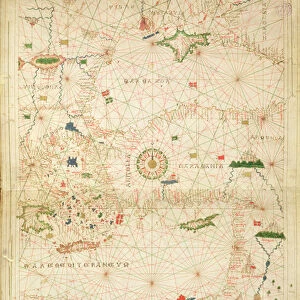
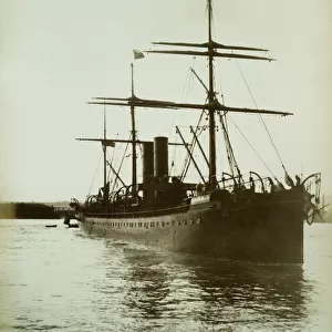
Canvas Print : Portolan chart of the Mediterranean and Northern Europe, c


![]()
Canvas Prints from Fine Art Finder
Portolan chart of the Mediterranean and Northern Europe, c
991250 Portolan chart of the Mediterranean and Northern Europe, c.1575-1600 (Illuminated manuscript on vellum) by Italian School, (16th century); 97x60 cm; Private Collection; (add.info.: Portolan chart of the Mediterranean and Northern Europe. Created by Jacopo Scotti (Giacomo Scotto, Jacobus Scotus). Italian School, (16th century). Illuminated manuscript on vellum. Levanto or Genoa, circa 1575-1600. 97 x 60cm.); Photo eChristies Images; Italian, out of copyright
Media ID 23675380
© Christie's Images / Bridgeman Images
1570s 1575 1600 1600s Compass Early Seventeenth Century Geographic Historic Event Historical Event Historical Events Human Like Human Likeness Illuminated Manuscript Italian Art Italian Artist Italian School Land Language Late Sixteenth Century Male Likeness Mediterranean Mediterranean Sea Navigational Equipment Northern Europe Olden Time On Vellum One Object Representation Single Object Natural Space Portolan Chart Scotus
30"x20" (76x51cm) Canvas Print
Transform your home or office into a captivating world of history with our Media Storehouse Canvas Prints featuring the intricately detailed Portolan Chart of the Mediterranean and Northern Europe. This stunning masterpiece, hailing from the Italian School of the late 16th to early 17th century, showcases an illuminated manuscript on vellum. With vibrant colors and meticulous detail, this Portolan chart brings the rich maritime history of the Mediterranean and Northern Europe to life. Each canvas print is carefully crafted using premium materials and high-definition printing techniques to ensure a museum-quality finish. Bring history into your space and elevate your decor with this exquisite work of art from Bridgeman Images through Fine Art Finder.
Delivered stretched and ready to hang our premium quality canvas prints are made from a polyester/cotton blend canvas and stretched over a 1.25" (32mm) kiln dried knot free wood stretcher bar. Packaged in a plastic bag and secured to a cardboard insert for safe transit.
Canvas Prints add colour, depth and texture to any space. Professionally Stretched Canvas over a hidden Wooden Box Frame and Ready to Hang
Estimated Product Size is 50.8cm x 76.2cm (20" x 30")
These are individually made so all sizes are approximate
Artwork printed orientated as per the preview above, with portrait (vertical) orientation to match the source image.
FEATURES IN THESE COLLECTIONS
> Animals
> Mammals
> Muridae
> Water Mouse
> Arts
> Artists
> I
> Italian School Italian School
> Arts
> Artists
> Related Images
> Europe
> France
> Canton
> Landes
> Europe
> Italy
> Liguria
> Genoa
> Maps and Charts
> Early Maps
> Maps and Charts
> Italy
> Maps and Charts
> Related Images
EDITORS COMMENTS
This print showcases a remarkable Portolan chart of the Mediterranean and Northern Europe, dating back to the late 16th century. Measuring at an impressive 97x60 cm, this illuminated manuscript on vellum is a true testament to the skill and artistry of Italian School artists from that era. Created by Jacopo Scotti (Giacomo Scotto), this intricately detailed map was likely produced in Levanto or Genoa between 1575-1600. The chart provides a comprehensive representation of land masses, seas, and navigational routes during that time period. The close-up view allows us to appreciate the fine craftsmanship and attention to detail put into every aspect of this historical artifact. The use of vibrant colors and delicate illustrations brings life to both the land and sea depicted on the chart. One cannot help but be drawn into this piece as it transports us back in time, offering a glimpse into early seventeenth-century geography. The inclusion of navigational equipment such as compasses adds an element of practicality to its artistic value. With no people present in the image, we are left solely with the beauty and significance of this historic document. It serves as a reminder not only of our past but also our continuous fascination with maps as tools for exploration and understanding.
MADE IN THE USA
Safe Shipping with 30 Day Money Back Guarantee
FREE PERSONALISATION*
We are proud to offer a range of customisation features including Personalised Captions, Color Filters and Picture Zoom Tools
SECURE PAYMENTS
We happily accept a wide range of payment options so you can pay for the things you need in the way that is most convenient for you
* Options may vary by product and licensing agreement. Zoomed Pictures can be adjusted in the Cart.