Canvas Print > Arts > Artists > D > Nicolas de Fer
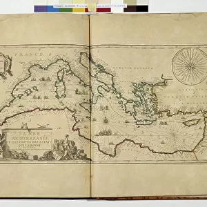
Canvas Print : Map of Asia, 1740 (hand-coloured engraving)
")
")


![]()
Canvas Prints from Fine Art Finder
Map of Asia, 1740 (hand-coloured engraving)
986320 Map of Asia, 1740 (hand-coloured engraving) by Fer, Nicolas de (1646-1720); 104x156 cm; Private Collection; (add.info.: Map of Asia; L Asie.... Nicolas de Fer (1646-1720). Hand-coloured engraving. Printed in Paris, by Danet and J.F. Bernard, 1740 (a reissue of the de Fer wall-map of 1700). 104 x 156cm.); Photo eChristies Images; French, out of copyright
Media ID 23686768
© Christie's Images / Bridgeman Images
1740 1740s Background People Bystander Geographic Hand Colored Hand Coloring Hand Coloured Hand Colouring Hand Tinted Handcolored Mid 18th Century Mid Eighteenth Century Navigational Equipment Pastel Pastel Coloured Prints
30"x20" (76x51cm) Canvas Print
Bring history to life with our exquisite Canvas Prints from Media Storehouse. This captivating Map of Asia, hand-colored engraving by Nicolas de Fer from Bridgeman Images, takes you back to the 18th century. Meticulously crafted on high-quality canvas, this vintage map is a stunning addition to any room, showcasing intricate details and vibrant colors. Travel back in time as you explore the rich history and geography of Asia with this beautiful work of art.
Delivered stretched and ready to hang our premium quality canvas prints are made from a polyester/cotton blend canvas and stretched over a 1.25" (32mm) kiln dried knot free wood stretcher bar. Packaged in a plastic bag and secured to a cardboard insert for safe transit.
Canvas Prints add colour, depth and texture to any space. Professionally Stretched Canvas over a hidden Wooden Box Frame and Ready to Hang
Estimated Product Size is 76.2cm x 50.8cm (30" x 20")
These are individually made so all sizes are approximate
Artwork printed orientated as per the preview above, with landscape (horizontal) orientation to match the source image.
FEATURES IN THESE COLLECTIONS
> Arts
> Artists
> D
> Nicolas de Fer
> Europe
> France
> Paris
> Maps
> Europe
> France
> Paris
> Related Images
> Fine Art Finder
> Artists
> German School
> Fine Art Finder
> Artists
> Nicolas de Fer
> Fine Art Finder
> Temp Classification
EDITORS COMMENTS
This print showcases a close-up of the "Map of Asia, 1740" a hand-coloured engraving by Nicolas de Fer. Measuring an impressive 104x156 cm, this exquisite piece is part of a private collection and offers a glimpse into the cartographic artistry of the eighteenth century. The map itself is meticulously detailed, depicting the vast expanse of Asia with precision and accuracy. Hand tinted in pastel colours, it radiates an air of elegance and sophistication that was characteristic of maps from this era. The skilled illustrator has beautifully captured not only the geographic features but also included navigational equipment to enhance its authenticity. As we delve deeper into this image, we notice bystanders admiring the map in awe. Their presence adds a human touch to an otherwise purely geographical representation. It reminds us that maps were not just tools for exploration but also objects that fascinated people during those times. The mid-eighteenth-century setting further immerses us in history as we appreciate both the craftsmanship behind this engraved artwork and its cultural significance at that time. The hand colouring technique employed here enhances every intricate detail, making it truly stand out against its background. Overall, this remarkable print invites us to marvel at Nicolas de Fer's masterpiece while offering insight into how maps were created centuries ago. Its combination of artistic beauty and historical importance makes it a true treasure for any admirer or collector alike.
MADE IN THE USA
Safe Shipping with 30 Day Money Back Guarantee
FREE PERSONALISATION*
We are proud to offer a range of customisation features including Personalised Captions, Color Filters and Picture Zoom Tools
SECURE PAYMENTS
We happily accept a wide range of payment options so you can pay for the things you need in the way that is most convenient for you
* Options may vary by product and licensing agreement. Zoomed Pictures can be adjusted in the Cart.