Canvas Print > Animals > Mammals > Muridae > Water Mouse
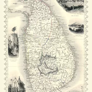
Canvas Print : Map of the island of Ceylon (Sri Lanka) (etching, 1730)
 (etching, 1730)")
 (etching, 1730)")


![]()
Canvas Prints from Fine Art Finder
Map of the island of Ceylon (Sri Lanka) (etching, 1730)
LRI4706764 Map of the island of Ceylon (Sri Lanka) (etching, 1730) by Delisle, Guillaume (1675-1726); Private Collection; (add.info.: Map of the island of Ceylon (Sri Lanka) - Strong water extracted from the " New Atlas containing all parts of the world" 1730 by Guillaume de L Isle (1675-1726)); Luisa Ricciarini; French, out of copyright
Media ID 22278666
© Luisa Ricciarini / Bridgeman Images
Atlas Book Sri Lanka Asian Asian Geographical Map
20"x16" (51x41cm) Canvas Print
Bring the historical charm of the past into your modern home with our Canvas Prints from Media Storehouse. This exquisite piece features an etching of a Map of the island of Ceylon (Sri Lanka) from 1730, created by renowned cartographer Guillaume Delisle. The intricate detail and antique aesthetic of Luisa Ricciarini's Fine Art Finder reproduction will transport you back in time. Each Canvas Print is meticulously crafted with premium materials, ensuring vibrant colors and sharp details that will last for years to come. Add a touch of history and sophistication to your decor with this beautiful and unique addition to your collection.
Delivered stretched and ready to hang our premium quality canvas prints are made from a polyester/cotton blend canvas and stretched over a 1.25" (32mm) kiln dried knot free wood stretcher bar. Packaged in a plastic bag and secured to a cardboard insert for safe transit.
Canvas Prints add colour, depth and texture to any space. Professionally Stretched Canvas over a hidden Wooden Box Frame and Ready to Hang
Estimated Product Size is 50.8cm x 40.6cm (20" x 16")
These are individually made so all sizes are approximate
Artwork printed orientated as per the preview above, with landscape (horizontal) orientation to match the source image.
FEATURES IN THESE COLLECTIONS
> Animals
> Mammals
> Muridae
> Water Mouse
> Asia
> Related Images
> Asia
> Sri Lanka
> Related Images
> Maps and Charts
> Related Images
> Maps and Charts
> World
> Fine Art Finder
> Artists
> Guillaume Delisle
EDITORS COMMENTS
This print showcases a remarkable etching from 1730, depicting the "Map of the island of Ceylon (Sri Lanka)" by Guillaume Delisle. The intricate details and exquisite craftsmanship of this geographical map are truly awe-inspiring. Originally featured in the renowned "New Atlas containing all parts of the world" this particular piece was extracted using strong water techniques. Guillaume de L'Isle, a prominent cartographer during his time, meticulously crafted this map to showcase the beauty and complexity of Sri Lanka's geography. The artist behind this stunning print is Luisa Ricciarini, who has skillfully captured every nuance and intricacy of Delisle's original work. Through her lens, we can appreciate not only the historical significance but also the artistic brilliance that went into creating such a masterpiece. As we gaze upon this image, we are transported back to the 18th century when exploration and cartography were at their peak. The map serves as a window into history, offering insights into how people perceived and understood distant lands during that era. Whether you have an affinity for Asian art or simply appreciate fine craftsmanship, this print is sure to captivate your imagination and spark curiosity about Sri Lanka's rich cultural heritage.
MADE IN THE USA
Safe Shipping with 30 Day Money Back Guarantee
FREE PERSONALISATION*
We are proud to offer a range of customisation features including Personalised Captions, Color Filters and Picture Zoom Tools
SECURE PAYMENTS
We happily accept a wide range of payment options so you can pay for the things you need in the way that is most convenient for you
* Options may vary by product and licensing agreement. Zoomed Pictures can be adjusted in the Cart.