Canvas Print > Animals > Mammals > Muridae > Water Mouse
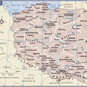
Canvas Print : Map of the Kingdom of Poland with the Duke of Lithuania (etching, 1730)
")
")


![]()
Canvas Prints from Fine Art Finder
Map of the Kingdom of Poland with the Duke of Lithuania (etching, 1730)
LRI4706592 Map of the Kingdom of Poland with the Duke of Lithuania (etching, 1730) by Delisle, Guillaume (1675-1726); Private Collection; (add.info.: Map of the Kingdom of Poland with the Duke of Lithuania - Strong water extracted from the " New Atlas containing all parts of the world" 1730 by Guillaume de L Isle (1675-1726)); Luisa Ricciarini; French, out of copyright
Media ID 23328060
© Luisa Ricciarini / Bridgeman Images
Atlas Book Baltic Countries Poland Polish Geographical Map
20"x16" (51x41cm) Canvas Print
Bring history to life with our exquisite Canvas Prints from Media Storehouse. This captivating etching, "Map of the Kingdom of Poland with the Duke of Lithuania" (LRI4706592), dates back to 1730, created by the renowned artist Guillaume Delisle. The intricate details of Luisa Ricciarini's Fine Art Finder reproduction will transport you back in time, showcasing the grandeur of the Polish-Lithuanian Commonwealth. Adorn your walls with this beautiful piece of art and let the story of the past unfold.
Delivered stretched and ready to hang our premium quality canvas prints are made from a polyester/cotton blend canvas and stretched over a 1.25" (32mm) kiln dried knot free wood stretcher bar. Packaged in a plastic bag and secured to a cardboard insert for safe transit.
Canvas Prints add colour, depth and texture to any space. Professionally Stretched Canvas over a hidden Wooden Box Frame and Ready to Hang
Estimated Product Size is 50.8cm x 40.6cm (20" x 16")
These are individually made so all sizes are approximate
Artwork printed orientated as per the preview above, with landscape (horizontal) orientation to match the source image.
FEATURES IN THESE COLLECTIONS
> Animals
> Mammals
> Muridae
> Water Mouse
> Europe
> Lithuania
> Posters
> Europe
> Lithuania
> Related Images
> Europe
> Poland
> Related Images
> Fine Art Finder
> Artists
> Guillaume Delisle
EDITORS COMMENTS
This etching, titled "Map of the Kingdom of Poland with the Duke of Lithuania" takes us back to 1730 when cartography was a true art form. Created by Guillaume Delisle, a renowned French geographer and cartographer, this map is an exquisite representation of the Polish-Lithuanian Commonwealth during its golden age. The intricate details and precision in this etching are truly remarkable. Every river, mountain range, and city is meticulously depicted, offering a glimpse into the geographical landscape of Eastern Europe at that time. The borders between countries are clearly defined, showcasing Poland's vast territory alongside its powerful neighbor Lithuania. What makes this particular print even more special is its origin from the "New Atlas containing all parts of the world". This comprehensive atlas compiled by de L'Isle was highly regarded for its accuracy and detailed maps. As we admire this piece today in our private collection, it serves as both a historical artifact and a work of art. It reminds us not only of Poland's rich history but also highlights the importance placed on geography during that era. Luisa Ricciarini has beautifully preserved this piece through her photography skills while respecting copyright laws. Through her lens, we can appreciate every delicate line and stroke made by Delisle over three centuries ago.
MADE IN THE USA
Safe Shipping with 30 Day Money Back Guarantee
FREE PERSONALISATION*
We are proud to offer a range of customisation features including Personalised Captions, Color Filters and Picture Zoom Tools
SECURE PAYMENTS
We happily accept a wide range of payment options so you can pay for the things you need in the way that is most convenient for you
* Options may vary by product and licensing agreement. Zoomed Pictures can be adjusted in the Cart.