Canvas Print > Europe > France > Canton > Ardennes
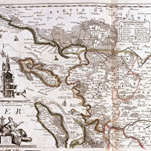
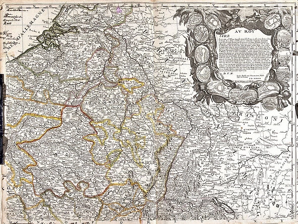
Canvas Print : Map of the Duche of Luxembourg, Champagne and Duche of Lorraine (Engraving, 1717)
")
")

![]()
Canvas Prints from Fine Art Finder
Map of the Duche of Luxembourg, Champagne and Duche of Lorraine (Engraving, 1717)
LRI4711512 Map of the Duche of Luxembourg, Champagne and Duche of Lorraine (Engraving, 1717) by Nolin, Jean-Baptiste (c.1657-1708); Private Collection; (add.info.: Map of the Duche of Luxembourg, Champagne and Duche of Lorraine (conquetes of the Kingdom of France during the War of the League of Augsburg, 1688-1697) - Engraving from the atlas le theatre du monde, 1717, by Jean Baptiste Nolin (1657-1708) - Map of Luxembourg, Champagne and Lorraine (France) - From " Le Theatre du Monde" 1717 by Jean-Baptiste Nolin); Luisa Ricciarini; French, out of copyright
Media ID 22837438
© Luisa Ricciarini / Bridgeman Images
Atlas Book Champagne Ardennes Lorraine Luxembourg Luxembourgish Geographical Map
20"x16" (51x41cm) Canvas Print
"Add a touch of historical elegance to your home decor with our Canvas Print of the Map of the Duche of Luxembourg, Champagne and Duche of Lorraine. This exquisite engraving, created by Jean-Baptiste Nolin in 1717, showcases intricate details of the territories ruled by the Duche of Luxembourg, Champagne, and Lorraine. Meticulously reproduced on high-quality canvas, this artwork brings a timeless charm to any room. Own a piece of history with the Map of the Duche of Luxembourg Canvas Print, exclusively available at Media Storehouse from Fine Art Finder." #LRI4711512 #HistoricalCanvasPrints #DucheofLuxembourg #Champagne #Lorraine #FineArtFinder #MediaStorehouse
Delivered stretched and ready to hang our premium quality canvas prints are made from a polyester/cotton blend canvas and stretched over a 1.25" (32mm) kiln dried knot free wood stretcher bar. Packaged in a plastic bag and secured to a cardboard insert for safe transit.
Canvas Prints add colour, depth and texture to any space. Professionally Stretched Canvas over a hidden Wooden Box Frame and Ready to Hang
Estimated Product Size is 50.8cm x 40.6cm (20" x 16")
These are individually made so all sizes are approximate
Artwork printed orientated as per the preview above, with landscape (horizontal) orientation to match the source image.
FEATURES IN THESE COLLECTIONS
> Europe
> France
> Canton
> Ardennes
> Europe
> Luxembourg
> Maps
> Europe
> Luxembourg
> Posters
> Europe
> Luxembourg
> Related Images
> Maps and Charts
> Luxembourg
> Maps and Charts
> Related Images
> Fine Art Finder
> Artists
> Jean-Baptiste Nolin
EDITORS COMMENTS
This engraving, titled "Map of the Duche of Luxembourg, Champagne and Duche of Lorraine" takes us back to the year 1717. Created by Jean-Baptiste Nolin, a renowned French cartographer, this intricate map showcases the territorial conquests of the Kingdom of France during the War of the League of Augsburg (1688-1697). The map offers a detailed depiction of Luxembourg, Champagne, and Lorraine – regions that witnessed significant historical events in France's past. It is part of Nolin's esteemed atlas called "Le Theatre du Monde" which was published in 1717. As we explore this piece further, we can appreciate its meticulous craftsmanship and attention to detail. The borders are intricately drawn with precision while various cities and towns are marked with tiny symbols. This visual representation allows us to understand not only geographical aspects but also political boundaries during that period. Luisa Ricciarini has skillfully captured this historic print through her lens, preserving it for future generations to admire. Through her photography expertise, she brings out every minute detail on this aged artwork. This photograph serves as a testament to both artistry and history coming together harmoniously. It reminds us how maps have always been essential tools for understanding our world's past and present landscapes.
MADE IN THE USA
Safe Shipping with 30 Day Money Back Guarantee
FREE PERSONALISATION*
We are proud to offer a range of customisation features including Personalised Captions, Color Filters and Picture Zoom Tools
SECURE PAYMENTS
We happily accept a wide range of payment options so you can pay for the things you need in the way that is most convenient for you
* Options may vary by product and licensing agreement. Zoomed Pictures can be adjusted in the Cart.