Canvas Print > Asia > Iraq > Maps
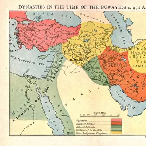
Canvas Print : Map of Assyria Chaldea and adjacent countries. From Cassell's Universal History, published 1888 (b/w engraving)
")

")


![]()
Canvas Prints from Fine Art Finder
Map of Assyria Chaldea and adjacent countries. From Cassell's Universal History, published 1888 (b/w engraving)
6867225 Map of Assyria Chaldea and adjacent countries. From Cassell's Universal History, published 1888 (b/w engraving); (add.info.: Map of Assyria Chaldea and adjacent countries. From Cassell's Universal History, published 1888.); Photo © Ken Welsh. All rights reserved 2024
Media ID 38333676
© © Ken Welsh. All rights reserved 2024 / Bridgeman Images
Assyria Assyrians Iraq Iraq Iraqi Mesopotamia Arab Civilization Arab Culture Arabians Geographer
20"x16" (51x41cm) Canvas Print
Explore the ancient world with our stunning canvas print featuring a detailed map of Assyria, Chaldea, and adjacent countries. Perfect for history buffs and art enthusiasts alike, this piece by Ken Welsh from Fine Art Finder is sure to add a touch of sophistication to any space.
Delivered stretched and ready to hang our premium quality canvas prints are made from a polyester/cotton blend canvas and stretched over a 1.25" (32mm) kiln dried knot free wood stretcher bar. Packaged in a plastic bag and secured to a cardboard insert for safe transit.
Canvas Prints add colour, depth and texture to any space. Professionally Stretched Canvas over a hidden Wooden Box Frame and Ready to Hang
Estimated Product Size is 50.8cm x 40.6cm (20" x 16")
These are individually made so all sizes are approximate
Artwork printed orientated as per the preview above, with landscape (horizontal) orientation to match the source image.
FEATURES IN THESE COLLECTIONS
> Asia
> Iraq
> Related Images
> Historic
> Ancient civilizations
> Mesopotamia
> Maps and Charts
> Early Maps
> Maps and Charts
> Related Images
> Fine Art Finder
> Artists
> Jean Delville
EDITORS COMMENTS
This stunning engraving from Cassell's Universal History, published in 1888, showcases a detailed Map of Assyria Chaldea and adjacent countries. The intricate cartography highlights the ancient lands of Assyria and Chaldea, providing a glimpse into the geography of the region during antiquity.
The map captures the historical significance of Mesopotamia, known for its rich heritage and contributions to civilization. It offers a window into the past, revealing the territories once inhabited by the Assyrians and their neighbors.
As you study this image, you can almost feel yourself transported back in time to an era when these lands were at the center of Arab civilization. The attention to detail in this engraving reflects the skill of both the geographer who created it and the engraver who brought it to life.
From Iraq to Arabia, this map encompasses a vast expanse of territory that played a crucial role in shaping Middle Eastern history. It serves as a reminder of our connection to ancient cultures and civilizations that have left an indelible mark on our world today.
Whether you are a history enthusiast or simply appreciate fine art, this print is sure to captivate your imagination with its depiction of a bygone era. Explore each intricately drawn detail and let yourself be transported through time with this remarkable piece from © Ken Welsh on Fine Art Finder.
MADE IN THE USA
Safe Shipping with 30 Day Money Back Guarantee
FREE PERSONALISATION*
We are proud to offer a range of customisation features including Personalised Captions, Color Filters and Picture Zoom Tools
SECURE PAYMENTS
We happily accept a wide range of payment options so you can pay for the things you need in the way that is most convenient for you
* Options may vary by product and licensing agreement. Zoomed Pictures can be adjusted in the Cart.