Canvas Print > North America > United States of America > New York > New York > Maps
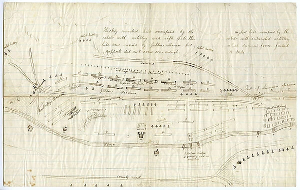
Canvas Print : Map of Fredericksburg, c. December 1862 (litho)
![]()

Canvas Prints from Fine Art Finder
Map of Fredericksburg, c. December 1862 (litho)
696115 Map of Fredericksburg, c.December 1862 (litho) by Bush, George (fl.1862); 25x39.5 cm; Gilder Lehrman Collection, New York, USA; (add.info.: A fairly complete and accurate map of the Union position at Fredericksburg. Shows federal positions, pontoon bridges, geographic features, roads and houses used as hospitals. The position held by Gibbons Division is slightly exaggerated.); eGilder Lehrman Institute of American History; American, out of copyright
Media ID 22954782
© Gilder Lehrman Institute of American History / Bridgeman Images
American Civil War Armies Mapping Positions Virginia Battle Of Fredericksburg Military Intelligence
30"x20" (76x51cm) Canvas Print
Bring the history of the American Civil War into your home with our stunning Canvas Print of the Map of Fredericksburg, c. December 1862. This beautiful lithograph, created by George Bush in 1862, offers a captivating glimpse into the strategic landscape of one of the most significant battles of the Civil War. The intricate details of the map, showcased in vibrant colors on a high-quality canvas, make it an impressive addition to any room. Relive the past and add a touch of history to your decor with our Canvas Print of the Map of Fredericksburg, c. December 1862 from Media Storehouse.
Delivered stretched and ready to hang our premium quality canvas prints are made from a polyester/cotton blend canvas and stretched over a 1.25" (32mm) kiln dried knot free wood stretcher bar. Packaged in a plastic bag and secured to a cardboard insert for safe transit.
Canvas Prints add colour, depth and texture to any space. Professionally Stretched Canvas over a hidden Wooden Box Frame and Ready to Hang
Estimated Product Size is 76.2cm x 50.8cm (30" x 20")
These are individually made so all sizes are approximate
Artwork printed orientated as per the preview above, with landscape (horizontal) orientation to match the source image.
FEATURES IN THESE COLLECTIONS
> Historic
> Battles
> Related Images
> Maps and Charts
> Related Images
> North America
> United States of America
> Maps
> North America
> United States of America
> New York
> New York
> Bridges
> Related Images
> North America
> United States of America
> New York
> New York
> Maps
> North America
> United States of America
> New York
> Related Images
> North America
> United States of America
> Virginia
> Related Images
> Fine Art Finder
> Artists
> John Montresor
> Fine Art Finder
> War & Military Scenes Pre-20th Century
EDITORS COMMENTS
This lithograph, titled "Map of Fredericksburg, c. December 1862" offers a glimpse into the strategic landscape during the American Civil War. Created by George Bush in 1862, this print measures 25x39.5 cm and is part of the Gilder Lehrman Collection in New York. The map provides a comprehensive and accurate depiction of the Union position at Fredericksburg during that time period. It highlights crucial details such as federal positions, pontoon bridges, geographic features, roads, and even houses used as hospitals. Notably, Gibbons Division's position is slightly exaggerated for clarity. As we examine this piece closely, it becomes evident that it served as an essential tool for military intelligence during the Battle of Fredericksburg. The meticulous cartography showcases both armies' positions on the battlefield with precision. Beyond its historical significance and military importance lies its artistic value. This engraving beautifully captures the essence of nineteenth-century mapping techniques while showcasing intricate details through expert sketching and drawing. With its rich historical context and visual allure, this lithograph transports us back to a pivotal moment in American history—the battle that took place in Fredericksburg in December 1862. As we explore each element within this print—each line drawn with purpose—we gain insight into how geography played a vital role in shaping warfare strategies during one of America's most tumultuous periods.
MADE IN THE USA
Safe Shipping with 30 Day Money Back Guarantee
FREE PERSONALISATION*
We are proud to offer a range of customisation features including Personalised Captions, Color Filters and Picture Zoom Tools
SECURE PAYMENTS
We happily accept a wide range of payment options so you can pay for the things you need in the way that is most convenient for you
* Options may vary by product and licensing agreement. Zoomed Pictures can be adjusted in the Cart.


