Canvas Print > North America > Nicaragua > Lakes > Lake Nicaragua
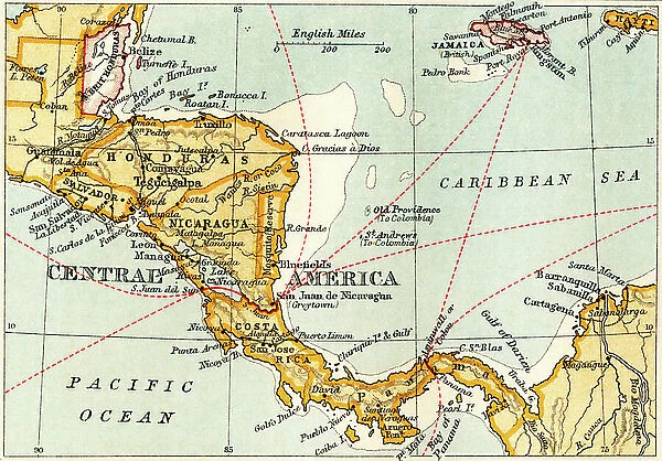
Canvas Print : Map showing the proposed Nicaraguan Canal Map showing the proposed Nicaraguan Canal, from "The Business Encyclopaedia and Legal Adviser", published 1907 (litho)
![]()

Canvas Prints from Fine Art Finder
Map showing the proposed Nicaraguan Canal Map showing the proposed Nicaraguan Canal, from "The Business Encyclopaedia and Legal Adviser", published 1907 (litho)
6428040 Map showing the proposed Nicaraguan Canal Map showing the proposed Nicaraguan Canal, from "The Business Encyclopaedia and Legal Adviser", published 1907 (litho) by English School, (20th century); (add.info.: Map showing the Nicaraguan Canal, a proposed shipping route through Nicaragua via Lake Nicaragua in the first decade of the 20th century, which would have connected the Atlantic and the Pacific Oceans. The plan never went ahead after the building of the Panama canal, from The Business Encyclopaedia and Legal Adviser, published 1907.); Photo © Ken Welsh. All rights reserved 2023
Media ID 28649685
© Ken Welsh. All rights reserved 2023 / Bridgeman Images
Acqueducts Ageing Atlantic Atlantic Ocean Central America Costa Rica Costarican Costaricans Elderly Man Old Age Old Couple Old Person Old Woman Outer Space Outerspace Pacific Ocean Planet Planetary Planets Run Down Senior Adult Space The Viaduct America Continent Geographical Map Lithos Litography Old Man
20"x16" (51x41cm) Canvas Print
Step back in time with our exclusive Media Storehouse Canvas Print featuring a captivating map from "The Business Encyclopaedia and Legal Adviser", published in 1907. This intriguing lithograph illustrates the proposed Nicaraguan Canal, a historic engineering project that captured the imagination of the world over a century ago. With meticulous attention to detail, this vintage map is brought to life on a high-quality canvas, adding an air of sophistication and intrigue to any room. Perfect for history enthusiasts, cartography collectors, or those who appreciate the beauty of the past, this unique piece is sure to be a conversation starter. Experience the allure of the past with Media Storehouse Canvas Prints.
Delivered stretched and ready to hang our premium quality canvas prints are made from a polyester/cotton blend canvas and stretched over a 1.25" (32mm) kiln dried knot free wood stretcher bar. Packaged in a plastic bag and secured to a cardboard insert for safe transit.
Canvas Prints add colour, depth and texture to any space. Professionally Stretched Canvas over a hidden Wooden Box Frame and Ready to Hang
Estimated Product Size is 50.8cm x 40.6cm (20" x 16")
These are individually made so all sizes are approximate
Artwork printed orientated as per the preview above, with landscape (horizontal) orientation to match the source image.
FEATURES IN THESE COLLECTIONS
> Arts
> Artists
> O
> Oceanic Oceanic
> Maps and Charts
> Early Maps
> Maps and Charts
> Related Images
> North America
> Costa Rica
> Maps
> North America
> Costa Rica
> Related Images
> North America
> Nicaragua
> Lakes
> Lake Nicaragua
> North America
> Nicaragua
> Lakes
> Related Images
> North America
> Nicaragua
> Maps
> North America
> Nicaragua
> Related Images
> Fine Art Finder
> Artists
> English School
> Fine Art Finder
> Artists
> Jules Goethals
EDITORS COMMENTS
This print showcases a map from "The Business Encyclopaedia and Legal Adviser" published in 1907, depicting the proposed Nicaraguan Canal. The lithograph displays the ambitious plan to create a shipping route through Nicaragua via Lake Nicaragua, connecting the Atlantic and Pacific Oceans. In the early 20th century, this visionary project aimed to rival the Panama Canal. However, history took a different turn as the construction of the Panama Canal became a reality, rendering this proposed Nicaraguan venture obsolete. This beautifully colored map serves as a testament to an unrealized dream that once held great promise for trade and transportation between continents. The image portrays more than just geographical details; it captures an era of exploration and innovation. It transports us back to a time when men dared to envision grand feats of engineering that could reshape global commerce. As we gaze upon this aged lithograph with its intricate cartography, we are reminded of how plans can change and dreams can evolve over time. The faded colors hint at both nostalgia for what might have been and admiration for human ingenuity. Through Ken Welsh's lens, we witness not only an old man-made creation but also our own planet's vastness within space—a reminder that even our greatest aspirations are mere specks in the cosmic tapestry.
MADE IN THE USA
Safe Shipping with 30 Day Money Back Guarantee
FREE PERSONALISATION*
We are proud to offer a range of customisation features including Personalised Captions, Color Filters and Picture Zoom Tools
SECURE PAYMENTS
We happily accept a wide range of payment options so you can pay for the things you need in the way that is most convenient for you
* Options may vary by product and licensing agreement. Zoomed Pictures can be adjusted in the Cart.


