Canvas Print > Europe > United Kingdom > England > Maps
Canvas Print : Map of England, c.1900 (engraving)
")
")


![]()
Canvas Prints from Fine Art Finder
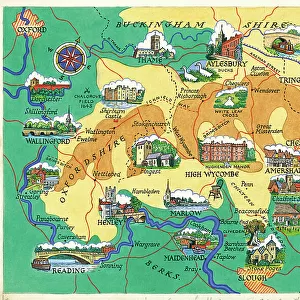
Map of England, c.1900 (engraving)
532908 Map of England, c.1900 (engraving); (add.info.: Map of England, including an inset of the Isle of Man, circa 1902, from the 10th edition of Encyclopaedia Britannica.); Encyclopaedia Britannica/UIG
Media ID 38138992
© Encyclopaedia Britannica/UIG / Bridgeman Images
1902 19th Century Style Guidance Illustration Technique Isle Of Man Meridian Navigational Equipment Old Fashioned Part Of Physical Geography The Past Western Script
20"x16" (51x41cm) Canvas Print
Explore our collection of stunning Canvas Prints featuring historical maps, such as this intricate engraving of "Map of England, c.1900" by Bridgeman Images from Fine Art Finder. Perfect for adding a touch of vintage charm to any space.
Delivered stretched and ready to hang our premium quality canvas prints are made from a polyester/cotton blend canvas and stretched over a 1.25" (32mm) kiln dried knot free wood stretcher bar. Packaged in a plastic bag and secured to a cardboard insert for safe transit.
Canvas Prints add colour, depth and texture to any space. Professionally Stretched Canvas over a hidden Wooden Box Frame and Ready to Hang
Estimated Product Size is 50.8cm x 40.6cm (20" x 16")
These are individually made so all sizes are approximate
Artwork printed orientated as per the preview above, with landscape (horizontal) orientation to match the source image.
FEATURES IN THESE COLLECTIONS
> Europe
> United Kingdom
> England
> Maps
> Europe
> United Kingdom
> England
> Paintings
> Europe
> United Kingdom
> Maps
> Europe
> United Kingdom
> Paintings
> Europe
> United Kingdom
> Scotland
> Western Isles
> Related Images
> Maps and Charts
> Related Images
> Fine Art Finder
> Temp Classification
EDITORS COMMENTS
This stunning engraving of a Map of England from around 1900 captures the intricate details and historical significance of cartography in the early 20th century. The map includes an inset of the Isle of Man, providing a comprehensive view of the British Isles during this time period.
As we gaze upon this piece, we are transported back to an era when navigation was reliant on physical maps and navigational equipment. The Western script used to label various locations adds a touch of old-fashioned charm to the map, reminding us of simpler times before GPS and digital mapping technology.
The detailed illustration showcases England's diverse physical geography, from its sprawling coastline to its bustling cities and rural landscapes. It serves as a valuable tool for exploration and understanding the country's topography.
This engraving is not just a map; it is a window into the past, offering insight into how our ancestors viewed their world. It reminds us of the importance of geography in shaping history and culture, making it a timeless piece that continues to fascinate viewers today.
Whether you're a history buff or simply appreciate beautiful artwork, this Map of England from c.1900 is sure to captivate your imagination with its rich detail and historical significance.
MADE IN THE USA
Safe Shipping with 30 Day Money Back Guarantee
FREE PERSONALISATION*
We are proud to offer a range of customisation features including Personalised Captions, Color Filters and Picture Zoom Tools
SECURE PAYMENTS
We happily accept a wide range of payment options so you can pay for the things you need in the way that is most convenient for you
* Options may vary by product and licensing agreement. Zoomed Pictures can be adjusted in the Cart.