Canvas Print > North America > United States of America > Wisconsin > Milwaukee
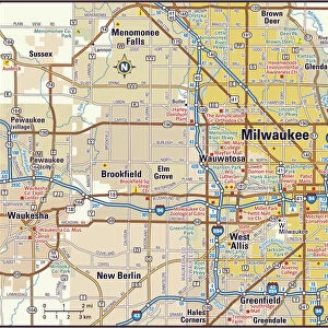
Canvas Print : Map of Milwaukee, c.1900 (engraving)
")
")
![]()
Canvas Prints from Fine Art Finder
Map of Milwaukee, c.1900 (engraving)
532798 Map of Milwaukee, c.1900 (engraving); (add.info.: Map of Milwaukee, Wisconsin, circa 1900, from the 10th edition of Encyclopaedia Britannica.); Encyclopaedia Britannica/UIG
Media ID 38453888
© Encyclopaedia Britannica/UIG / Bridgeman Images
1900 19th Century Style City Map Cut Out Guidance Illustration Technique Lake Michigan Meridian Milwaukee Navigational Equipment Old Fashioned Panoramic Physical Geography The Past Western Script White Background Wisconsin
21"x7" (53x18cm) Canvas Print
Explore the historic charm of Milwaukee with this stunning canvas print featuring a detailed map from c.1900. Perfect for adding a touch of vintage elegance to any space, this piece is sure to be a conversation starter in your home or office.
Delivered stretched and ready to hang our premium quality canvas prints are made from a polyester/cotton blend canvas and stretched over a 1.25" (32mm) kiln dried knot free wood stretcher bar. Packaged in a plastic bag and secured to a cardboard insert for safe transit.
Canvas Prints add colour, depth and texture to any space. Professionally Stretched Canvas over a hidden Wooden Box Frame and Ready to Hang
Estimated Product Size is 53.3cm x 17.8cm (21" x 7")
These are individually made so all sizes are approximate
Artwork printed orientated as per the preview above, with landscape (horizontal) orientation to match the source image.
FEATURES IN THESE COLLECTIONS
> Maps and Charts
> Related Images
> North America
> United States of America
> Lakes
> Lake Michigan
> North America
> United States of America
> Lakes
> Related Images
> North America
> United States of America
> Maps
> North America
> United States of America
> Michigan
> Related Images
> North America
> United States of America
> Wisconsin
> Milwaukee
> North America
> United States of America
> Wisconsin
> Related Images
> Fine Art Finder
> Temp Classification
EDITORS COMMENTS
This stunning engraving of a Map of Milwaukee, circa 1900, offers a glimpse into the past with its intricate details and old-fashioned charm. The map, originally featured in the 10th edition of Encyclopaedia Britannica, showcases the city's physical geography and navigational points with western script on a clean white background.
As you study this piece, you can almost imagine explorers using it as a guide to navigate through the bustling city streets and along the shores of Lake Michigan. The careful attention to detail in this illustration technique captures the essence of Milwaukee at the turn of the century.
With no people in sight, this panoramic view allows us to appreciate the craftsmanship that went into creating such an accurate representation of Milwaukee's layout. From meridians to landmarks, every element is meticulously rendered for both practical use and aesthetic appeal.
Whether you have roots in Milwaukee or simply appreciate historical cartography, this print is sure to spark your curiosity about how cities were mapped out in days gone by. Let yourself be transported back in time as you explore this piece from Bridgeman Images' collection on Fine Art Finder.
MADE IN THE USA
Safe Shipping with 30 Day Money Back Guarantee
FREE PERSONALISATION*
We are proud to offer a range of customisation features including Personalised Captions, Color Filters and Picture Zoom Tools
SECURE PAYMENTS
We happily accept a wide range of payment options so you can pay for the things you need in the way that is most convenient for you
* Options may vary by product and licensing agreement. Zoomed Pictures can be adjusted in the Cart.