Canvas Print > Europe > Norway > Maps
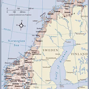
Canvas Print : Map of Norway and Sweden, c.1900 (engraving)
")
")

![]()
Canvas Prints from Fine Art Finder
Map of Norway and Sweden, c.1900 (engraving)
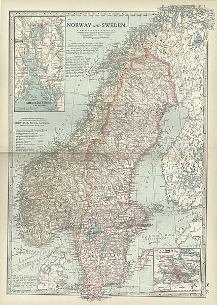
532971 Map of Norway and Sweden, c.1900 (engraving); (add.info.: Map of Norway, Sweden, with insets of Kristianiafjord and Stockholm, circa 1902, from the 10th edition of Encyclopaedia Britannica.); Encyclopaedia Britannica/UIG
Media ID 38310264
© Encyclopaedia Britannica/UIG / Bridgeman Images
1902 19th Century Style Boundary Geographical Border Guidance Illustration Technique Meridian Navigational Equipment Norway Norway Norwegian Norwegian Norwegians Old Fashioned Physical Geography Stockholm Sverige Sweden The Past Western Script
20"x16" (51x41cm) Canvas Print
Explore the beauty of Scandinavia with our stunning canvas print featuring a vintage map of Norway and Sweden from 1900. Perfect for adding a touch of history and charm to any space.
Delivered stretched and ready to hang our premium quality canvas prints are made from a polyester/cotton blend canvas and stretched over a 1.25" (32mm) kiln dried knot free wood stretcher bar. Packaged in a plastic bag and secured to a cardboard insert for safe transit.
Canvas Prints add colour, depth and texture to any space. Professionally Stretched Canvas over a hidden Wooden Box Frame and Ready to Hang
Estimated Product Size is 40.6cm x 50.8cm (16" x 20")
These are individually made so all sizes are approximate
Artwork printed orientated as per the preview above, with portrait (vertical) orientation to match the source image.
FEATURES IN THESE COLLECTIONS
> Europe
> Norway
> Related Images
> Europe
> Sweden
> Related Images
> Fine Art Finder
> Temp Classification
EDITORS COMMENTS
This stunning engraving of a Map of Norway and Sweden from around 1900 captures the intricate details of these Scandinavian countries with precision and artistry. The map, originally featured in the 10th edition of Encyclopaedia Britannica, showcases the geographical borders, coastlines, and navigational points of Norway and Sweden.
The inclusion of insets highlighting Kristianiafjord and Stockholm adds depth to this historical cartographic piece. The old-fashioned style evokes a sense of nostalgia for a bygone era when exploration was at the forefront of discovery.
As you study this vertical representation, you can almost imagine sailors using it as a guide across the sea or travelers planning their next adventure through Europe. The meridians and boundaries are meticulously drawn, emphasizing the importance placed on accurate mapping during this time period.
Whether you have a personal connection to Norway or Sweden or simply appreciate fine illustration techniques, this print is sure to captivate your imagination. Let yourself be transported back to 1902 as you explore the rich history and beauty captured in this timeless depiction of two remarkable countries in Scandinavia.
MADE IN THE USA
Safe Shipping with 30 Day Money Back Guarantee
FREE PERSONALISATION*
We are proud to offer a range of customisation features including Personalised Captions, Color Filters and Picture Zoom Tools
SECURE PAYMENTS
We happily accept a wide range of payment options so you can pay for the things you need in the way that is most convenient for you
* Options may vary by product and licensing agreement. Zoomed Pictures can be adjusted in the Cart.