
Canvas Print > Maps and Charts > Flat Earth
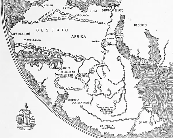
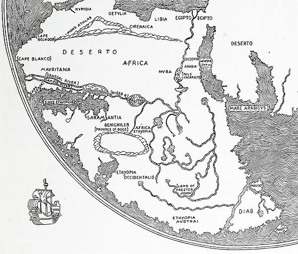
Canvas Print : Sketch of Africa from Fra Mauro's Great Map of the World, 1457


![]()
Canvas Prints from Fine Art Finder
Sketch of Africa from Fra Mauro's Great Map of the World, 1457
1578440 Sketch of Africa from Fra Mauro's Great Map of the World, 1457; (add.info.: Sketch of Africa from Fra Mauro's Great Map of the World, 1457); Universal History Archive/UIG
Media ID 38310650
© Universal History Archive/UIG / Bridgeman Images
Explorers Flat Earth Fra Mauro
20"x16" (51x41cm) Canvas Print
Bring a piece of history into your home with this stunning canvas print featuring a sketch of Africa from Fra Mauro's Great Map of the World, dating back to 1457. A unique and timeless addition to any art collection.
Delivered stretched and ready to hang our premium quality canvas prints are made from a polyester/cotton blend canvas and stretched over a 1.25" (32mm) kiln dried knot free wood stretcher bar. Packaged in a plastic bag and secured to a cardboard insert for safe transit.
Canvas Prints add colour, depth and texture to any space. Professionally Stretched Canvas over a hidden Wooden Box Frame and Ready to Hang
Estimated Product Size is 50.8cm x 40.6cm (20" x 16")
These are individually made so all sizes are approximate
Artwork printed orientated as per the preview above, with landscape (horizontal) orientation to match the source image.
FEATURES IN THESE COLLECTIONS
> Maps and Charts
> Flat Earth
> Maps and Charts
> World
> Fine Art Finder
> Temp Classification
EDITORS COMMENTS
This sketch of Africa from Fra Mauro's Great Map of the World, created in 1457, offers a glimpse into the intricate world of cartography during the Age of Exploration. The detailed lines and symbols on this ancient map reveal the vastness and diversity of the African continent as seen through the eyes of early explorers.
Fra Mauro, a Venetian monk and cartographer, meticulously crafted this map using information gathered from various sources including travelers, merchants, and sailors. His dedication to accuracy and detail is evident in every stroke of his pen as he sought to create a comprehensive representation of the known world at that time.
As we gaze upon this historical artifact, we are transported back in time to an era when maps were not just tools for navigation but also works of art that sparked curiosity and wonder about distant lands. The sketch captures Africa's unique geography with its rivers, mountains, deserts, and coastlines - inviting us to imagine the adventures and discoveries made by early explorers who ventured into unknown territories.
This print serves as a reminder of humanity's enduring fascination with exploration and discovery. It is a testament to our innate desire to understand our place in the world and uncover its mysteries one map at a time.
MADE IN THE USA
Safe Shipping with 30 Day Money Back Guarantee
FREE PERSONALISATION*
We are proud to offer a range of customisation features including Personalised Captions, Color Filters and Picture Zoom Tools
SECURE PAYMENTS
We happily accept a wide range of payment options so you can pay for the things you need in the way that is most convenient for you
* Options may vary by product and licensing agreement. Zoomed Pictures can be adjusted in the Cart.


