Canvas Print > Africa > Tunisia > Maps
Canvas Print : Map of african coasts from Ras El Hadid (Algeria) to Cap Negre (Tunisia), 1821, engraving
 to Cap Negre (Tunisia), 1821, engraving")
 to Cap Negre (Tunisia), 1821, engraving")


![]()
Canvas Prints from Fine Art Finder
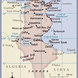
Map of african coasts from Ras El Hadid (Algeria) to Cap Negre (Tunisia), 1821, engraving
1754351 Map of african coasts from Ras El Hadid (Algeria) to Cap Negre (Tunisia), 1821, engraving; (add.info.: Map of african coasts from Ras El Hadid (Algeria) to Cap Negre (Tunisia), 1821, engraving); Photo: Tallandier
Media ID 38205072
© Photo: Tallandier / Bridgeman Images
30"x20" (76x51cm) Canvas Print
Explore the rich history and intricate details of North African coastlines with our Canvas Print featuring an engraving from 1821. Perfect for adding a touch of vintage charm to your home decor.
Delivered stretched and ready to hang our premium quality canvas prints are made from a polyester/cotton blend canvas and stretched over a 1.25" (32mm) kiln dried knot free wood stretcher bar. Packaged in a plastic bag and secured to a cardboard insert for safe transit.
Canvas Prints add colour, depth and texture to any space. Professionally Stretched Canvas over a hidden Wooden Box Frame and Ready to Hang
Estimated Product Size is 76.2cm x 50.8cm (30" x 20")
These are individually made so all sizes are approximate
Artwork printed orientated as per the preview above, with landscape (horizontal) orientation to match the source image.
FEATURES IN THESE COLLECTIONS
> Africa
> Algeria
> Related Images
> Africa
> Tunisia
> Related Images
> Maps and Charts
> Early Maps
> Maps and Charts
> Related Images
EDITORS COMMENTS
This engraving from 1821 showcases a detailed map of the African coasts from Ras El Hadid in Algeria to Cap Negre in Tunisia. The intricate lines and markings on the map provide a glimpse into the historical significance of this region during the 19th century.
As you study this print, you can almost feel yourself traveling back in time to an era when exploration and discovery were at the forefront of human endeavors. The coastlines are meticulously outlined, giving us a sense of the vastness and diversity of these North African territories.
The engraving exudes a sense of mystery and adventure, inviting us to delve deeper into the rich history that lies within these lands. From bustling ports to hidden coves, each detail on this map tells a story waiting to be uncovered.
Whether you have a passion for cartography or simply appreciate the beauty of historical artwork, this print is sure to captivate your imagination. It serves as a reminder of the interconnectedness of cultures across borders and invites us to explore new horizons both geographically and intellectually.
MADE IN THE USA
Safe Shipping with 30 Day Money Back Guarantee
FREE PERSONALISATION*
We are proud to offer a range of customisation features including Personalised Captions, Color Filters and Picture Zoom Tools
SECURE PAYMENTS
We happily accept a wide range of payment options so you can pay for the things you need in the way that is most convenient for you
* Options may vary by product and licensing agreement. Zoomed Pictures can be adjusted in the Cart.