Canvas Print > Maps and Charts > Germany
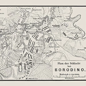
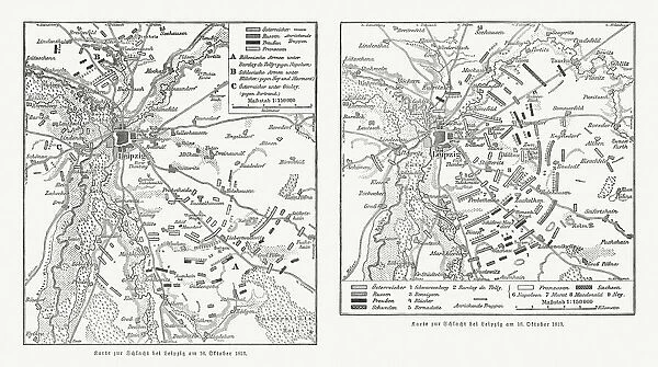
Canvas Print : Maps of Battle of Leipzig, Napolionic wars, 1813, published 1897


![]()
Canvas Prints from Fine Art Storehouse
Maps of Battle of Leipzig, Napolionic wars, 1813, published 1897
Maps of the Battle of the Nations near Leipzig from 16 to 19 October 1813, Saxony, Germany. Wood engravings, published in 1897
Unleash your creativity and transform your space into a visual masterpiece!
ZU_09
Media ID 18356533
30"x20" (76x51cm) Canvas Print
"Step back in time with our stunning Canvas Print of the Battle of Leipzig Map from the Napoleonic Wars. Published in 1897, this intricately detailed wood engraving by ZU_09 from our Media Storehouse Fine Art collection, captures the strategic layout of the Battle of the Nations near Leipzig, Germany, during the fateful year of 1813. Perfect for history enthusiasts, this beautiful canvas print adds a touch of historical significance and sophistication to any room in your home or office. Bring the past to life with this exquisite piece of art."
Delivered stretched and ready to hang our premium quality canvas prints are made from a polyester/cotton blend canvas and stretched over a 1.25" (32mm) kiln dried knot free wood stretcher bar. Packaged in a plastic bag and secured to a cardboard insert for safe transit.
Canvas Prints add colour, depth and texture to any space. Professionally Stretched Canvas over a hidden Wooden Box Frame and Ready to Hang
Estimated Product Size is 76.2cm x 50.8cm (30" x 20")
These are individually made so all sizes are approximate
Artwork printed orientated as per the preview above, with landscape (horizontal) orientation to match the source image.
FEATURES IN THESE COLLECTIONS
> Historic
> Battles
> Related Images
> Maps and Charts
> Related Images
> Fine Art Storehouse
> History
> Battles & Wars
> Historcal Battle Maps and Plans
> Fine Art Storehouse
> Map
> Historical Maps
EDITORS COMMENTS
This print showcases a historical treasure - the Maps of the Battle of Leipzig, which took place during the Napoleonic Wars in 1813. Published in 1897, these wood engravings provide a fascinating glimpse into one of the most significant conflicts in European history. The Battle of Leipzig, also known as the Battle of Nations, was fought near Leipzig, Saxony (Germany) from 16 to 19 October 1813. It marked a turning point in Napoleon Bonaparte's reign and ultimately led to his downfall. These meticulously detailed maps offer an intricate depiction of the battlefield and its surroundings. As we examine this print closely, we are transported back in time to witness the strategic maneuvers and intense clashes that unfolded over those four fateful days. The precision with which each line is etched on paper reflects both artistic skill and historical accuracy. Beyond their aesthetic appeal, these maps hold immense educational value for historians and enthusiasts alike. They serve as invaluable resources for studying military tactics employed during this era and understanding how geopolitical landscapes were shaped by war. ZU_09's masterful capture ensures that every detail is preserved with utmost clarity, allowing us to immerse ourselves fully in this pivotal moment from two centuries ago. This print truly encapsulates not only artistry but also serves as a window into our collective past – reminding us of the sacrifices made by countless individuals who fought bravely on those hallowed grounds at Leipzig.
MADE IN THE USA
Safe Shipping with 30 Day Money Back Guarantee
FREE PERSONALISATION*
We are proud to offer a range of customisation features including Personalised Captions, Color Filters and Picture Zoom Tools
SECURE PAYMENTS
We happily accept a wide range of payment options so you can pay for the things you need in the way that is most convenient for you
* Options may vary by product and licensing agreement. Zoomed Pictures can be adjusted in the Cart.