Canvas Print > Arts > Artists > O > Oceanic Oceanic
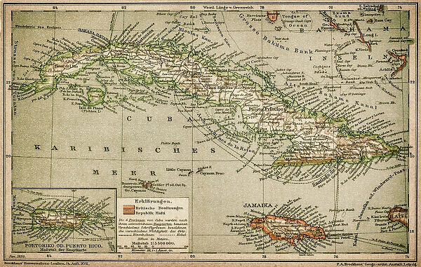
Canvas Print : Caribbean map


![]()
Canvas Prints from Fine Art Storehouse
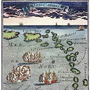
Caribbean map
Antique map of Cuba, Jamaica, Puerto Rico
Unleash your creativity and transform your space into a visual masterpiece!
Nastasic
Media ID 13592957
© Nikola Nastasic
Atlantic Ocean Caribbean Caribbean Sea Central America Cuba Dominican Republic Equator Line French Overseas Territory Island Jamaica Puerto Rico Southern Usa The Americas Antigua Leeward Islands Guadeloupe Obsolete
30"x20" (76x51cm) Canvas Print
"Transport yourself to the enchanting Caribbean with the "Caribbean Map" Canvas Print from Media Storehouse's Fine Art Storehouse collection. This beautiful antique map, created by Nastasic, showcases the captivating details of Cuba, Jamaica, and Puerto Rico in their historic context. The high-quality canvas print brings a touch of timeless charm and adventure to any space, making it an exquisite addition to your home or office decor. With its vibrant colors and intricate details, this map is not just a piece of art, but a journey through history. Order your "Caribbean Map" Canvas Print today and let the magic of the islands come alive in your living room!"
Delivered stretched and ready to hang our premium quality canvas prints are made from a polyester/cotton blend canvas and stretched over a 1.25" (32mm) kiln dried knot free wood stretcher bar. Packaged in a plastic bag and secured to a cardboard insert for safe transit.
Canvas Prints add colour, depth and texture to any space. Professionally Stretched Canvas over a hidden Wooden Box Frame and Ready to Hang
Estimated Product Size is 76.2cm x 50.8cm (30" x 20")
These are individually made so all sizes are approximate
Artwork printed orientated as per the preview above, with landscape (horizontal) orientation to match the source image.
FEATURES IN THESE COLLECTIONS
> Arts
> Artists
> O
> Oceanic Oceanic
> Maps and Charts
> Early Maps
> Maps and Charts
> Related Images
> North America
> Antigua and Barbuda
> Maps
> North America
> Cuba
> Maps
> North America
> Cuba
> Related Images
> North America
> Dominican Republic
> Maps
> Fine Art Storehouse
> The Magical World of Illustration
> Nastasic Images & Illustrations
> Fine Art Storehouse
> Map
> Historical Maps
> Fine Art Storehouse
> Map
> USA Maps
EDITORS COMMENTS
This print showcases an exquisite antique map of the Caribbean, featuring Cuba, Jamaica, and Puerto Rico as its focal points. The intricate cartography transports us back in time to a bygone era when these islands held great historical significance. The obsolete nature of this map adds to its allure, reminding us of the ever-evolving world we live in. The equator line prominently displayed on this horizontal artwork serves as a reminder of the geographical location of these enchanting destinations within Central America and Southern USA. As our eyes wander across the image, we are drawn towards other notable landmarks such as Antigua Leeward Islands, Guadeloupe, Dominican Republic, and more. The rich history embedded within each stroke of this ancient illustration takes us on a journey through time. It encapsulates the essence of exploration and discovery that defined the Americas during their early days. With every glance at this print, we can almost feel the warm Caribbean breeze caressing our skin while envisioning tales from sailors who once navigated these turquoise waters. As waves crash against sandy shores along the vast expanse of the Caribbean Sea and Atlantic Ocean depicted on this map, it becomes evident why these islands have captivated travelers for centuries. This print is not just an artistic masterpiece; it is a gateway to unraveling stories etched into every inch.
MADE IN THE USA
Safe Shipping with 30 Day Money Back Guarantee
FREE PERSONALISATION*
We are proud to offer a range of customisation features including Personalised Captions, Color Filters and Picture Zoom Tools
SECURE PAYMENTS
We happily accept a wide range of payment options so you can pay for the things you need in the way that is most convenient for you
* Options may vary by product and licensing agreement. Zoomed Pictures can be adjusted in the Cart.