Canvas Print > Fine Art Storehouse > Map
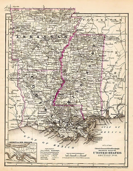
Canvas Print : Arkansas Louisiana Pississippi map 1881


![]()
Canvas Prints from Fine Art Storehouse
Arkansas Louisiana Pississippi map 1881
Coltons Common School Geography 1881 New York Sheldon and Co
Unleash your creativity and transform your space into a visual masterpiece!
THEPALMER
Media ID 13669249
© This content is subject to copyright
American Culture Arkansas Globe Navigational Equipment Gulf Coast States Louisiana Mississippi North America Paper Planet Earth World Map
20"x16" (51x41cm) Canvas Print
Step back in time with our exquisite Canvas Print of the Arkansas, Louisiana, and Mississippi Map from 1881. This vintage geography piece, sourced from Colton's Common School Geography published by Sheldon and Co, New York, showcases intricate detail and beautiful cartography from a bygone era. The Canvas Print by THEPALMER from our Media Storehouse Fine Art collection brings history to life in your home, adding an air of sophistication and character to any room. With its rich colors and high-quality finish, this Canvas Print is not just a map, but a work of art that tells a story. Transport yourself back to the late 19th century and explore the history of the American South with this stunning piece.
Delivered stretched and ready to hang our premium quality canvas prints are made from a polyester/cotton blend canvas and stretched over a 1.25" (32mm) kiln dried knot free wood stretcher bar. Packaged in a plastic bag and secured to a cardboard insert for safe transit.
Canvas Prints add colour, depth and texture to any space. Professionally Stretched Canvas over a hidden Wooden Box Frame and Ready to Hang
Estimated Product Size is 40.6cm x 50.8cm (16" x 20")
These are individually made so all sizes are approximate
Artwork printed orientated as per the preview above, with portrait (vertical) orientation to match the source image.
FEATURES IN THESE COLLECTIONS
> Fine Art Storehouse
> The Magical World of Illustration
> Palmer Illustrated Collection
> Fine Art Storehouse
> Map
> Historical Maps
> Fine Art Storehouse
> Map
> USA Maps
EDITORS COMMENTS
This print titled "Arkansas Louisiana Pississippi map 1881" takes us on a journey back in time to the late 19th century. The image showcases an exquisite engraving from Coltons Common School Geography, published in New York by Sheldon and Co. in 1881. The map itself is a testament to the artistry and precision of cartography during that era. It depicts the states of Arkansas, Mississippi, and Louisiana along with their surrounding regions, including the Gulf Coast states. This vintage piece offers a glimpse into American culture at that time, showcasing how these states were interconnected through trade routes and geographical features. The intricate details of this engraved image are truly remarkable. Every contour line, river system, and mountain range has been meticulously etched onto paper, creating a visually stunning representation of physical geography. As we examine this antique map closely, it becomes evident that it was not only a navigational tool but also an artistic masterpiece. Displayed against a backdrop of globe navigational equipment adds another layer of intrigue to this photograph print. It serves as a reminder that maps like these were once essential tools for explorers and adventurers seeking knowledge about our planet Earth. "The Arkansas Louisiana Pississippi map 1881" by THEPALMER is more than just an old piece of paper; it encapsulates history within its delicate engravings while offering us insight into the world as it was over a century ago.
MADE IN THE USA
Safe Shipping with 30 Day Money Back Guarantee
FREE PERSONALISATION*
We are proud to offer a range of customisation features including Personalised Captions, Color Filters and Picture Zoom Tools
SECURE PAYMENTS
We happily accept a wide range of payment options so you can pay for the things you need in the way that is most convenient for you
* Options may vary by product and licensing agreement. Zoomed Pictures can be adjusted in the Cart.