Canvas Print > Europe > Denmark > Maps
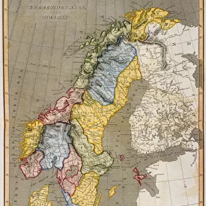
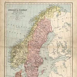
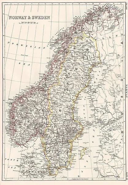
Canvas Print : Norway and Sweden map 1884


![]()
Canvas Prints from Fine Art Storehouse
Norway and Sweden map 1884
Encyclopedia Britannica 9th Edition New York Charles Scribners and Sonsl 1884 Vol XVII
Unleash your creativity and transform your space into a visual masterpiece!
THEPALMER
Media ID 14756702
© This content is subject to copyright
Denmark Norway Scandinavia Sweden
20"x16" (51x41cm) Canvas Print
Transport yourself to the captivating landscapes of Norway and Sweden with our exquisite Canvas Print of the 1884 map by THEPALMER from the Fine Art Storehouse at Media Storehouse. This intricately detailed map, originally published in the Encyclopedia Britannica 9th Edition by Charles Scribner's Sons, New York, showcases the rich history and geography of these two magnificent countries. The high-quality canvas material and vibrant colors bring out the intricate lines and borders, making it a stunning addition to any home or office decor. Travel back in time and explore the beauty of Norway and Sweden with this beautiful piece of historical cartography.
Delivered stretched and ready to hang our premium quality canvas prints are made from a polyester/cotton blend canvas and stretched over a 1.25" (32mm) kiln dried knot free wood stretcher bar. Packaged in a plastic bag and secured to a cardboard insert for safe transit.
Canvas Prints add colour, depth and texture to any space. Professionally Stretched Canvas over a hidden Wooden Box Frame and Ready to Hang
Estimated Product Size is 40.6cm x 50.8cm (16" x 20")
These are individually made so all sizes are approximate
Artwork printed orientated as per the preview above, with portrait (vertical) orientation to match the source image.
FEATURES IN THESE COLLECTIONS
> Europe
> Denmark
> Related Images
> Europe
> Norway
> Related Images
> Europe
> Sweden
> Related Images
> Fine Art Storehouse
> Map
> Denmark Maps
> Fine Art Storehouse
> Map
> Historical Maps
EDITORS COMMENTS
In this print titled "Norway and Sweden map 1884" we are transported back in time to the late 19th century, where cartography was an art form in itself. This particular piece is a reproduction from the Encyclopedia Britannica's 9th Edition, published by Charles Scribners and Sons in New York. The intricate details of this vintage map showcase the geographical landscape of Norway and Sweden during that era. The delicate lines trace the borders of these two Scandinavian countries, highlighting their unique shapes and contours. As our eyes wander across the print, we can almost feel ourselves embarking on a historical journey through these enchanting lands. The faded hues lend an air of nostalgia to the image, evoking a sense of wonder about how much has changed since then. It serves as a reminder that maps not only provide directions but also serve as windows into history - capturing moments frozen in time. "ThePALMER" has skillfully captured this piece with precision and care, ensuring that every detail is faithfully reproduced for us to admire. Whether you have an affinity for geography or simply appreciate vintage artwork, this print will undoubtedly add a touch of elegance and intrigue to any space it graces. Allow yourself to be transported back in time with "Norway and Sweden map 1884" where history meets artistry in perfect harmony.
MADE IN THE USA
Safe Shipping with 30 Day Money Back Guarantee
FREE PERSONALISATION*
We are proud to offer a range of customisation features including Personalised Captions, Color Filters and Picture Zoom Tools
SECURE PAYMENTS
We happily accept a wide range of payment options so you can pay for the things you need in the way that is most convenient for you
* Options may vary by product and licensing agreement. Zoomed Pictures can be adjusted in the Cart.