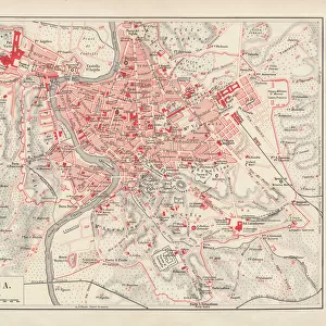
Canvas Print > Europe > Italy > Lazio > Rome
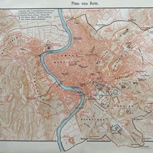
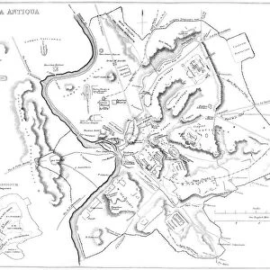
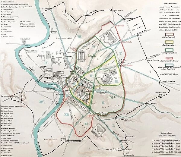
Canvas Print : Ancient rome, regions map of Rome


![]()
Canvas Prints from Fine Art Storehouse
Ancient rome, regions map of Rome
Illustration from 19th century
Unleash your creativity and transform your space into a visual masterpiece!
clu
Media ID 18298719
20"x16" (51x41cm) Canvas Print
Discover the rich history and culture of Ancient Rome with our exquisite Canvas Print from the Media Storehouse collection. This captivating piece, titled "Ancient Rome, Regions Map of Rome" by clu from Fine Art Storehouse, is an illustration from the 19th century that transports you back in time. The intricate details of this vintage map beautifully depict the various regions of the ancient city, making it a stunning addition to any home or office. Elevate your space with this timeless and educational artwork, expertly printed on high-quality canvas to bring out the vibrant colors and textures of the original illustration. Experience the grandeur of Ancient Rome in your own home with Media Storehouse's Canvas Prints.
Delivered stretched and ready to hang our premium quality canvas prints are made from a polyester/cotton blend canvas and stretched over a 1.25" (32mm) kiln dried knot free wood stretcher bar. Packaged in a plastic bag and secured to a cardboard insert for safe transit.
Canvas Prints add colour, depth and texture to any space. Professionally Stretched Canvas over a hidden Wooden Box Frame and Ready to Hang
Estimated Product Size is 50.8cm x 40.6cm (20" x 16")
These are individually made so all sizes are approximate
Artwork printed orientated as per the preview above, with landscape (horizontal) orientation to match the source image.
FEATURES IN THESE COLLECTIONS
> Europe
> Italy
> Lazio
> Rome
> Maps and Charts
> Early Maps
> Maps and Charts
> Related Images
> Fine Art Storehouse
> Map
> Historical Maps
EDITORS COMMENTS
This print takes us back in time to Ancient Rome, offering a glimpse into the intricate regions that once made up this magnificent city. Illustrated during the 19th century, this map provides an invaluable historical perspective on the ancient civilization's territorial divisions. As we explore the image, our eyes are immediately drawn to the remarkable level of detail and precision with which each region is depicted. From Aventine Hill to Palatine Hill, from Esquiline Hill to Quirinal Hill, every district comes alive with its own unique characteristics and landmarks. The artist's skillful rendering transports us through time and space, allowing us to envision what life might have been like for Romans living in these distinct neighborhoods. The sepia tones used in this print lend it an air of nostalgia and authenticity, further enhancing its appeal as a piece of art that not only educates but also evokes emotions. It serves as a reminder of Rome's rich history and cultural heritage that has left an indelible mark on Western civilization. Whether displayed in a classroom or adorning the walls of a history enthusiast's home, this print offers both aesthetic beauty and educational value. It invites viewers to immerse themselves in the grandeur of Ancient Rome while appreciating the artistic talent behind its creation.
MADE IN THE USA
Safe Shipping with 30 Day Money Back Guarantee
FREE PERSONALISATION*
We are proud to offer a range of customisation features including Personalised Captions, Color Filters and Picture Zoom Tools
SECURE PAYMENTS
We happily accept a wide range of payment options so you can pay for the things you need in the way that is most convenient for you
* Options may vary by product and licensing agreement. Zoomed Pictures can be adjusted in the Cart.