Canvas Print > Fine Art Storehouse > Map
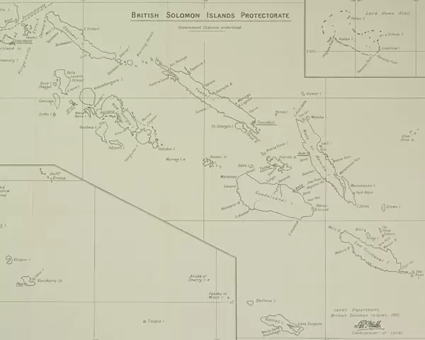
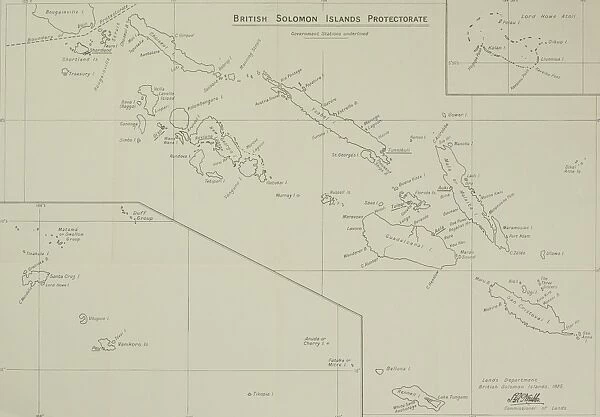
Canvas Print : Antique map of British Solomon Islands Protectorate


![]()
Canvas Prints from Fine Art Storehouse
Antique map of British Solomon Islands Protectorate
Unleash your creativity and transform your space into a visual masterpiece!
Hemera Technologies
Media ID 13609537
© Getty Images
Archipelago Coordinates Direction Document Geography Land Legend Location Place Positioning Territory Title Insets Quadrants
20"x16" (51x41cm) Canvas Print
Step back in time with our exquisite Antique Map of British Solomon Islands Protectorate Canvas Print from the Media Storehouse Fine Art Collection. This stunning piece, brought to you by Hemera Technologies, transports you to a bygone era with its intricate details and vibrant colors. The map, depicting the British territories in the South Pacific during the late 19th century, is a captivating conversation starter and adds a touch of historical charm to any room. Printed on high-quality canvas and meticulously crafted, this work of art is sure to impress and inspire.
Delivered stretched and ready to hang our premium quality canvas prints are made from a polyester/cotton blend canvas and stretched over a 1.25" (32mm) kiln dried knot free wood stretcher bar. Packaged in a plastic bag and secured to a cardboard insert for safe transit.
Canvas Prints add colour, depth and texture to any space. Professionally Stretched Canvas over a hidden Wooden Box Frame and Ready to Hang
Estimated Product Size is 50.8cm x 40.6cm (20" x 16")
These are individually made so all sizes are approximate
Artwork printed orientated as per the preview above, with landscape (horizontal) orientation to match the source image.
FEATURES IN THESE COLLECTIONS
> Fine Art Storehouse
> Map
> Historical Maps
EDITORS COMMENTS
This antique map of the British Solomon Islands Protectorate takes us on a journey through time, offering a glimpse into the rich history and geography of this archipelago. Crafted with precision and care, this archival print showcases the intricate details engraved by Hemera Technologies. The map is adorned with elegant quadrants, each revealing different aspects of the territory's physical geography. Insets provide further insights into specific locations within the protectorate, while a key and legend guide our understanding of symbols and coordinates used throughout. As we immerse ourselves in this vintage masterpiece, we can't help but appreciate its historical significance. It serves as both a document and an art form that captures not only land boundaries but also cultural heritage. The horizontal composition allows us to explore every corner effortlessly, while vibrant colors bring life to previously uncharted territories. This color image transports us back in time without any distractions from modern civilization or human presence. Whether you are an avid cartography enthusiast or simply fascinated by history, this antique map offers a unique opportunity to connect with the past. Let it ignite your curiosity about British Solomon Islands Protectorate's intriguing past as you embark on your own exploration through its beautifully depicted landscapes.
MADE IN THE USA
Safe Shipping with 30 Day Money Back Guarantee
FREE PERSONALISATION*
We are proud to offer a range of customisation features including Personalised Captions, Color Filters and Picture Zoom Tools
SECURE PAYMENTS
We happily accept a wide range of payment options so you can pay for the things you need in the way that is most convenient for you
* Options may vary by product and licensing agreement. Zoomed Pictures can be adjusted in the Cart.