Canvas Print > Maps and Charts > Americas
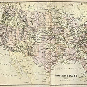
Canvas Print : Antique map of United States, 1897, late 19th Century


![]()
Canvas Prints from Fine Art Storehouse
Antique map of United States, 1897, late 19th Century
Vintage engraving of a Antique map of United States of America, 1897, late 19th Century
Unleash your creativity and transform your space into a visual masterpiece!
duncan1890
Media ID 18206107
© of Duncan P Walker
20"x16" (51x41cm) Canvas Print
Step back in time with our exquisite Canvas Print of an Antique Map of the United States, hailing from the late 19th Century. This captivating vintage engraving, sourced from the Fine Art Storehouse under the artist name duncan1890, beautifully depicts the United States as it existed in 1897. The intricate details and rich colors of this map are brought to life on high-quality canvas, creating a stunning piece of art that adds character and history to any room. Perfect for history enthusiasts, cartography lovers, or anyone seeking to add a touch of timeless charm to their decor. Order now and let this Antique Map Canvas Print transport you back to a bygone era.
Delivered stretched and ready to hang our premium quality canvas prints are made from a polyester/cotton blend canvas and stretched over a 1.25" (32mm) kiln dried knot free wood stretcher bar. Packaged in a plastic bag and secured to a cardboard insert for safe transit.
Canvas Prints add colour, depth and texture to any space. Professionally Stretched Canvas over a hidden Wooden Box Frame and Ready to Hang
Estimated Product Size is 50.8cm x 40.6cm (20" x 16")
These are individually made so all sizes are approximate
Artwork printed orientated as per the preview above, with landscape (horizontal) orientation to match the source image.
FEATURES IN THESE COLLECTIONS
> Maps and Charts
> Related Images
> North America
> United States of America
> Related Images
> Fine Art Storehouse
> Map
> Historical Maps
EDITORS COMMENTS
This print showcases an exquisite antique map of the United States, dating back to 1897. A true relic from the late 19th century, this vintage engraving captures the essence of a bygone era when cartography was both art and science. The intricate details etched onto this map tell a story of exploration, expansion, and discovery. As we gaze upon this historical masterpiece, our eyes are drawn to the delicate lines that outline each state's borders. From coast to coast, it is evident how much America has evolved over time. This antique map serves as a visual time capsule, transporting us back to an era where territories were still being defined and boundaries were constantly shifting. The craftsmanship displayed in this print is truly remarkable; every river and mountain range meticulously engraved with precision. It reminds us of the dedication and skill required by those early cartographers who painstakingly created these maps by hand. With its warm sepia tones and aged appearance, this photograph evokes a sense of nostalgia for simpler times. It invites us to reflect on our nation's rich history while marveling at how far we have come since then. Whether you're a history enthusiast or simply appreciate fine artistry, this antique map print will undoubtedly add character and charm to any space it graces. Let it transport you back in time as you explore the vastness of America through the lens of yesteryears' cartographic brilliance.
MADE IN THE USA
Safe Shipping with 30 Day Money Back Guarantee
FREE PERSONALISATION*
We are proud to offer a range of customisation features including Personalised Captions, Color Filters and Picture Zoom Tools
SECURE PAYMENTS
We happily accept a wide range of payment options so you can pay for the things you need in the way that is most convenient for you
* Options may vary by product and licensing agreement. Zoomed Pictures can be adjusted in the Cart.