Canvas Print > Oceania > Australia > Maps
Canvas Print : Antique Map of Victoria, Australia


![]()
Canvas Prints from Fine Art Storehouse
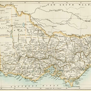
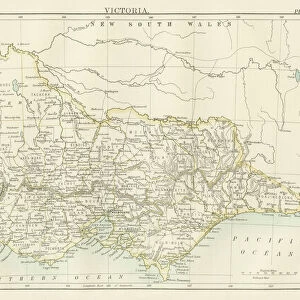
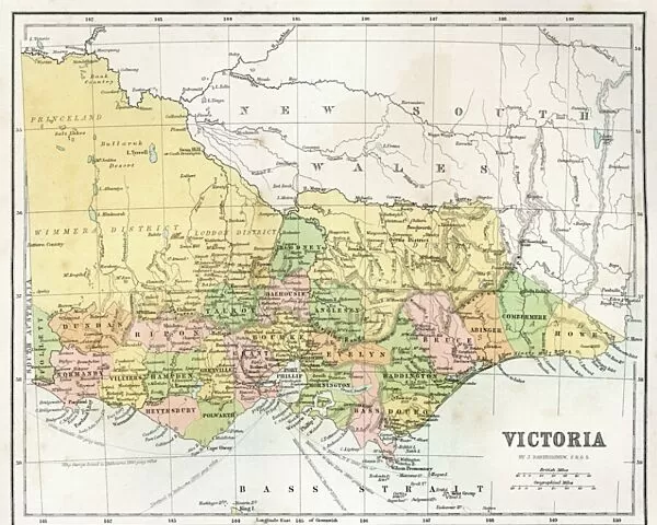
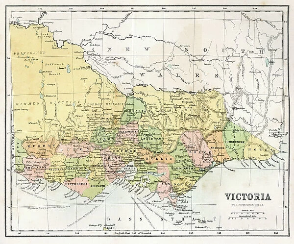
Antique Map of Victoria, Australia
Antique map of the State of Victoria, Australia, from 1867
Unleash your creativity and transform your space into a visual masterpiece!
duncan1890
Media ID 19746097
© Duncan Walker
Discovery Bay Mildura Torquay Yarra Valley
20"x16" (51x41cm) Canvas Print
"Discover the rich history of Victoria, Australia with our stunning Antique Map Canvas Print by duncan1890 from the Media Storehouse Fine Art Collection. This beautiful piece, originally created in 1867, showcases intricate details and vibrant colors that bring the past to life. Perfect for adding a unique touch to your home or office decor, our Canvas Prints are made using premium materials and high-definition printing techniques to ensure a stunning, museum-quality finish. Travel back in time and celebrate the history and culture of Victoria with this captivating Antique Map Canvas Print."
Delivered stretched and ready to hang our premium quality canvas prints are made from a polyester/cotton blend canvas and stretched over a 1.25" (32mm) kiln dried knot free wood stretcher bar. Packaged in a plastic bag and secured to a cardboard insert for safe transit.
Canvas Prints add colour, depth and texture to any space. Professionally Stretched Canvas over a hidden Wooden Box Frame and Ready to Hang
Estimated Product Size is 50.8cm x 40.6cm (20" x 16")
These are individually made so all sizes are approximate
Artwork printed orientated as per the preview above, with landscape (horizontal) orientation to match the source image.
FEATURES IN THESE COLLECTIONS
> Maps and Charts
> Related Images
> Oceania
> Australia
> Related Images
> Fine Art Storehouse
> Map
> Historical Maps
EDITORS COMMENTS
This print showcases an exquisite Antique Map of Victoria, Australia, dating back to 1867. Crafted with meticulous detail and precision by the talented artist Duncan1890, this piece takes us on a journey through time to explore the rich history and geographical wonders of this beautiful state. The map encompasses various notable locations such as Point Henry, Mildura, Torquay, Yarra Valley, Noorat, Discovery Bay, and more. Each name etched onto the aged parchment carries its own story and significance in shaping Victoria's past. As we delve into this antique masterpiece, we are transported back to an era when cartography was both artistry and science. The intricate lines tracing rivers and mountains reflect the dedication put forth by those who mapped these lands centuries ago. With each glance at this print, one can't help but marvel at how far we have come since then. It serves as a reminder of our connection to the past while also igniting curiosity about what lies beyond these borders today. Whether you are a history enthusiast or simply appreciate fine art that captures the essence of a place's heritage, this Antique Map of Victoria is sure to captivate your imagination. Display it proudly in your home or office space as a testament to the timeless beauty found within historical cartography.
MADE IN THE USA
Safe Shipping with 30 Day Money Back Guarantee
FREE PERSONALISATION*
We are proud to offer a range of customisation features including Personalised Captions, Color Filters and Picture Zoom Tools
SECURE PAYMENTS
We happily accept a wide range of payment options so you can pay for the things you need in the way that is most convenient for you
* Options may vary by product and licensing agreement. Zoomed Pictures can be adjusted in the Cart.