Canvas Print > Arts > Artists > O > Oceanic Oceanic
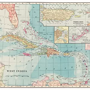
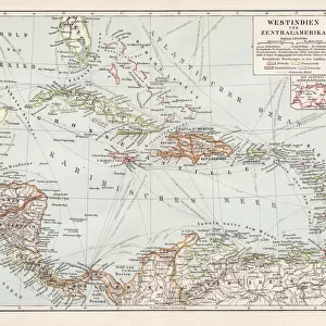
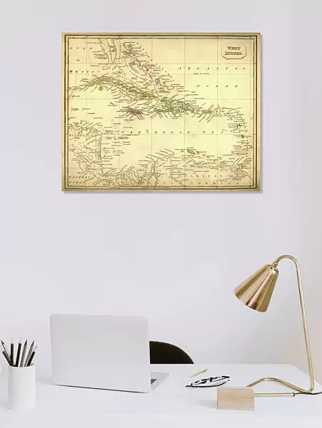
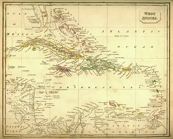
Canvas Print : Antquie Map of The West Indies


![]()
Canvas Prints from Fine Art Storehouse
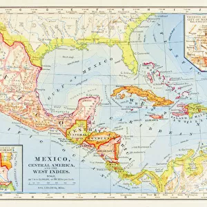
Antquie Map of The West Indies
Vintage map of The West Indies from 1837
Unleash your creativity and transform your space into a visual masterpiece!
duncan1890
Media ID 13666635
© duncan1890
Antilles Atlantic Islands Atlantic Ocean Bahamas Barbados Bermuda Caribbean Caribbean Culture Caribbean Sea Cayman Islands Chart Cuba Dominican Republic Geographical Locations Greater Antilles Gulf Of Mexico Haiti Hispaniola Jamaica Latin America Lesser Antilles Manufactured Object Navigational Equipment Objects Equipment Past Puerto Rico Styles The Americas Trinidad And Tobago West Indies Windward Islands Caribbean French Antilles Image Created 19th Century Leeward Islands Obsolete Victorian Style Windward Islands
20"x16" (51x41cm) Canvas Print
"Step back in time with our exquisite Canvas Print of the Antique Map of The West Indies by duncan1890 from our Media Storehouse Fine Art Collection. This vintage map, originally published in 1837, beautifully captures the historical details of the West Indies during that era. Each Canvas Print is meticulously crafted using premium materials and high-definition printing techniques to bring out the intricate details and rich colors of the map. Add a touch of history and character to your home or office decor with this stunning piece of art."
Delivered stretched and ready to hang our premium quality canvas prints are made from a polyester/cotton blend canvas and stretched over a 1.25" (32mm) kiln dried knot free wood stretcher bar. Packaged in a plastic bag and secured to a cardboard insert for safe transit.
Canvas Prints add colour, depth and texture to any space. Professionally Stretched Canvas over a hidden Wooden Box Frame and Ready to Hang
Estimated Product Size is 50.8cm x 40.6cm (20" x 16")
These are individually made so all sizes are approximate
Artwork printed orientated as per the preview above, with landscape (horizontal) orientation to match the source image.
FEATURES IN THESE COLLECTIONS
> Arts
> Artists
> O
> Oceanic Oceanic
> Maps and Charts
> Related Images
> North America
> The Bahamas
> Maps
> North America
> The Bahamas
> Related Images
> North America
> Barbados
> Maps
> North America
> Barbados
> Related Images
> North America
> Bermuda
> Maps
> Fine Art Storehouse
> Map
> Historical Maps
EDITORS COMMENTS
This vintage print takes us on a journey back in time to the 19th century, immersing us in the rich history and culture of the West Indies. The meticulously engraved image showcases an antique map from 1837, featuring intricate details and a Victorian style that transports us to another era. As we explore this antiquated cartographic masterpiece, we are reminded of the bygone days when navigational equipment and charts were essential tools for seafarers. The map encompasses a vast expanse of geographical locations, including Bermuda, Bahamas, Puerto Rico, Cuba, Jamaica, and many more enchanting islands scattered across the Caribbean Sea. The faded hues and delicate lines evoke a sense of nostalgia as we delve into the forgotten past. We can almost envision sailors poring over this very map aboard their ships as they ventured through these azure waters towards new horizons. Beyond its historical significance lies a deeper appreciation for Caribbean culture; it serves as a gateway to understanding the diverse heritage of nations such as Haiti, Trinidad and Tobago, Barbados, Dominican Republic - all nestled within this vibrant archipelago known as the West Indies. Duncan1890's expert photography captures every nuance of this manufactured object with utmost precision. This print is not just an image but rather an invitation to immerse oneself in centuries-old stories woven into each contour line on this beautifully preserved piece of art.
MADE IN THE USA
Safe Shipping with 30 Day Money Back Guarantee
FREE PERSONALISATION*
We are proud to offer a range of customisation features including Personalised Captions, Color Filters and Picture Zoom Tools
SECURE PAYMENTS
We happily accept a wide range of payment options so you can pay for the things you need in the way that is most convenient for you
* Options may vary by product and licensing agreement. Zoomed Pictures can be adjusted in the Cart.